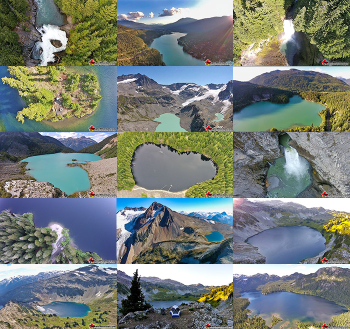
![]() Aerial views of Whistler hiking trails give you a nice perspective on how beautiful this part of the world is. Wedge Glacier is hard to grasp its immensity from across the valley. Up close, from above, the endless rows of crevasses and massive contours give this hulking glacier a more complete picture.
Aerial views of Whistler hiking trails give you a nice perspective on how beautiful this part of the world is. Wedge Glacier is hard to grasp its immensity from across the valley. Up close, from above, the endless rows of crevasses and massive contours give this hulking glacier a more complete picture.
Whistler & Garibaldi Hiking
![]() Alexander Falls
Alexander Falls ![]() Ancient Cedars
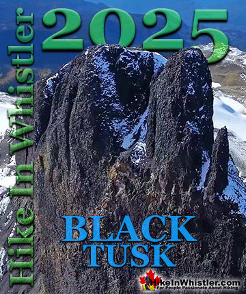
Ancient Cedars ![]() Black Tusk
Black Tusk ![]() Blackcomb Mountain
Blackcomb Mountain ![]() Brandywine Falls
Brandywine Falls ![]() Brandywine Meadows
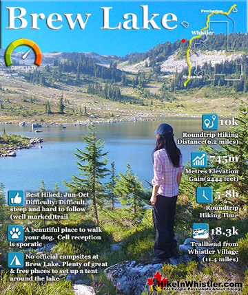
Brandywine Meadows ![]() Brew Lake
Brew Lake ![]() Callaghan Lake
Callaghan Lake ![]() Cheakamus Lake
Cheakamus Lake ![]() Cheakamus River
Cheakamus River ![]() Cirque Lake
Cirque Lake ![]() Flank Trail
Flank Trail ![]() Garibaldi Lake
Garibaldi Lake ![]() Garibaldi Park
Garibaldi Park ![]() Helm Creek
Helm Creek ![]() Jane Lakes
Jane Lakes ![]() Joffre Lakes
Joffre Lakes ![]() Keyhole Hot Springs
Keyhole Hot Springs ![]() Logger’s Lake
Logger’s Lake ![]() Madeley Lake
Madeley Lake ![]() Meager Hot Springs
Meager Hot Springs ![]() Nairn Falls
Nairn Falls ![]() Newt Lake
Newt Lake ![]() Panorama Ridge
Panorama Ridge ![]() Parkhurst Ghost Town
Parkhurst Ghost Town ![]() Rainbow Falls
Rainbow Falls ![]() Rainbow Lake
Rainbow Lake ![]() Ring Lake
Ring Lake ![]() Russet Lake
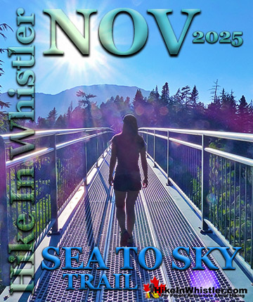
Russet Lake ![]() Sea to Sky Trail
Sea to Sky Trail ![]() Skookumchuck Hot Springs
Skookumchuck Hot Springs ![]() Sloquet Hot Springs
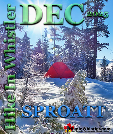
Sloquet Hot Springs ![]() Sproatt East
Sproatt East ![]() Sproatt West
Sproatt West ![]() Taylor Meadows
Taylor Meadows ![]() Train Wreck
Train Wreck ![]() Wedgemount Lake
Wedgemount Lake ![]() Whistler Mountain
Whistler Mountain
Whistler Aerial Views
![]() Alexander
Alexander ![]() Brandywine
Brandywine ![]() Blackcomb
Blackcomb ![]() Callaghan
Callaghan ![]() Cirque
Cirque ![]() Joffre
Joffre ![]() Keyhole
Keyhole ![]() Logger's
Logger's ![]() Madeley
Madeley ![]() Panorama
Panorama ![]() Sproatt
Sproatt ![]() Parkhurst
Parkhurst ![]() Rainbow
Rainbow ![]() Russet
Russet ![]() Train Wreck
Train Wreck ![]() Wedge Glacier
Wedge Glacier ![]() Wedgemount
Wedgemount ![]() Whistler
Whistler
The mountains around Wedgemount Lake tower around the valley and seeing them in profile is a great way to grasp the wild, chaotic, boulder strewn landscape below. Along with Wedge Glacier and Wedgemount Lake we have some great aerial views of Panorama Ridge, Parkhurst Ghost Town, Russet Lake, Adit Lakes, Overlord Mountain, Overlord Glacier, Whistler Mountain, Blackcomb Mountain, Brandywine Falls, Alexander Falls, Joffre Lakes, Logger's Lake, Whistler Train Wreck. In the Callaghan Valley we have some nice views of Callaghan Lake Provincial Park. High above Callaghan Lake we have some aerial views of Cirque Lake. Above and beyond Cirque Lake still more views of the Sky Lakes. High above the Sky Lakes, the distant Cirque Lake is wonderfully framed by Mount Callaghan at an angle that is not often seen. Another beautiful lake in the Callaghan Valley is Madeley Lake. This idyllic mountain lake is put into perspective with an aerial view of a person floating in the middle on an Explorer 200. As the camera rises to several hundred metres the person becomes a speck in the middle of a glassy calm lake. One mountain away from Madeley Lake, we have some more aerial views of Rainbow Lake. The water source for Whistler, Rainbow Lake has a stunning view across the valley to Wedge Mountain, Blackcomb Mountain, Whistler Mountain and the Whistler Valley below. Towering near Rainbow Lake and across from Rainbow Mountain is Mount Sproatt. We have some interesting aerial views of the vast Sproatt alpine. Hidden from view across the valley from Whistler Mountain, Mount Sproatt hides a massively expansive alpine terrain of valleys, meadows, cliffs, ridges, tarns and in the last few years, trails.

Cirque Lake - Best Whistler Aerial Views
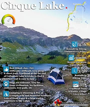
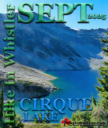
![]() Cirque Lake is a beautiful mountain lake hidden up alongside Mount Callaghan in Callaghan Lake Provincial Park. The trailhead is tricky to find and located at the far end of Callaghan Lake. You can only reach the trailhead by boat and the trail is quite steep but very short. Less than two kilometres long the steep trail hugs Cirque Creek and Cirque Falls up to Cirque Lake. The lake itself sits in a huge cirque along the north side of Mount Callaghan and is untouched by humanity. Cirque Lake is well into the alpine so you won't need to find hiking trails as the alpine is wide open for hiking. A fairly easy route along the right side of the lake takes you further into the alpine along the right edge of the cirque. This alpine leads to more alpine lakes that descend like steps down into the valley below. At Cirque Lake you will find few areas of ground suitable for a tent.
Cirque Lake is a beautiful mountain lake hidden up alongside Mount Callaghan in Callaghan Lake Provincial Park. The trailhead is tricky to find and located at the far end of Callaghan Lake. You can only reach the trailhead by boat and the trail is quite steep but very short. Less than two kilometres long the steep trail hugs Cirque Creek and Cirque Falls up to Cirque Lake. The lake itself sits in a huge cirque along the north side of Mount Callaghan and is untouched by humanity. Cirque Lake is well into the alpine so you won't need to find hiking trails as the alpine is wide open for hiking. A fairly easy route along the right side of the lake takes you further into the alpine along the right edge of the cirque. This alpine leads to more alpine lakes that descend like steps down into the valley below. At Cirque Lake you will find few areas of ground suitable for a tent.
Cirque Lake Campsite in Paradise

Cirque Lake Sunset Aerial View

Cirque Lake and Mount Callaghan Aerial View

The rugged terrain is rocky and buried in snow most of the year. The snow retreats from along the shore of Cirque Lake in mid to late July, but the trail is mostly free of snow by early July. At less than two kilometres, the Cirque Lake trail is steep, however not too steep to require technical skill. Callaghan Lake Provincial Park doesn't prohibit dogs, making the Cirque Lake trail one of the few hiking trails in Whistler that is dog friendly. The steep trail and necessity of canoeing to the trailhead make Cirque Lake far less hiked than other Whistler area hiking trails. The alpine beyond Cirque Lake is even less popular with hikers and you rarely see anyone up there on even the sunniest summer days. More aerial views, details, directions and maps for Cirque Lake.
Keyhole Falls - Best Whistler Aerial Views
![]() Keyhole Falls are found just a couple kilometres upriver from Keyhole Hot Springs. The unmarked trailhead and parking area for Keyhole Falls are just a couple kilometres past the parking area for Keyhole Hot Springs. If you don't have a rough idea where it is, or expect an obvious sign, you will likely get lost in the maze of logging roads in the area. Mount Meager looms high above Keyhole Hot Springs and it, and the surrounding peaks are known collectively as the Mount Meager Complex. The Meager Complex produced the most recent, major volcanic event in Canada in the last 10,000 years. The eruption 2400 years ago spread ash as far as Alberta. More recently, in 2010 a massive debris flow swept down and into the valley causing Pemberton to be evacuated. The eruption 2400 years ago left a huge pumice outcrop 2 kilometres long and 1 kilometre wide. Keyhole Hot Springs is located 100 kilometres from Whistler(Village Gate Blvd). Though most of the 100 kilometres is on logging roads, it is driveable by most cars without any trouble.
Keyhole Falls are found just a couple kilometres upriver from Keyhole Hot Springs. The unmarked trailhead and parking area for Keyhole Falls are just a couple kilometres past the parking area for Keyhole Hot Springs. If you don't have a rough idea where it is, or expect an obvious sign, you will likely get lost in the maze of logging roads in the area. Mount Meager looms high above Keyhole Hot Springs and it, and the surrounding peaks are known collectively as the Mount Meager Complex. The Meager Complex produced the most recent, major volcanic event in Canada in the last 10,000 years. The eruption 2400 years ago spread ash as far as Alberta. More recently, in 2010 a massive debris flow swept down and into the valley causing Pemberton to be evacuated. The eruption 2400 years ago left a huge pumice outcrop 2 kilometres long and 1 kilometre wide. Keyhole Hot Springs is located 100 kilometres from Whistler(Village Gate Blvd). Though most of the 100 kilometres is on logging roads, it is driveable by most cars without any trouble.
Keyhole Falls in the Distance

Keyhole Falls From Above

Keyhole Falls From Above - Close Up

Meager Slide Debris Field in 2013

Meager Slide Debris Field in 2014

Callaghan Lake - Best Whistler Aerial Views
![]() Callaghan Lake is a stunning lake high up in the Callaghan Valley that you can drive to from Whistler Village in less than an hour. The very potholed and waterbar strewn gravel road to get there ends at the Callaghan Lake Provincial Park campsite and shore of the lake. Hardly any hiking trails exist at the lake itself, however trails are being planned for the near future. There is an amazing trail that starts at the far end of the lake to Cirque Lake as well as a trail from the Callaghan Lake campsite to Ring Lake. The Ring Lake trail takes you around Mount Callaghan to this beautiful mountain paradise while the Cirque Lake trail takes you far up alongside Mount Callaghan. Most visitors to Callaghan Lake Provincial Park camp or stay close to the main campsite area and paddle around the lake. The lake is surrounded by pristine wilderness and endless white capped mountains. There are dozens of interesting places along the shore to pull up your canoe and explore the wilderness or just find a sunny hilltop for a picnic.
Callaghan Lake is a stunning lake high up in the Callaghan Valley that you can drive to from Whistler Village in less than an hour. The very potholed and waterbar strewn gravel road to get there ends at the Callaghan Lake Provincial Park campsite and shore of the lake. Hardly any hiking trails exist at the lake itself, however trails are being planned for the near future. There is an amazing trail that starts at the far end of the lake to Cirque Lake as well as a trail from the Callaghan Lake campsite to Ring Lake. The Ring Lake trail takes you around Mount Callaghan to this beautiful mountain paradise while the Cirque Lake trail takes you far up alongside Mount Callaghan. Most visitors to Callaghan Lake Provincial Park camp or stay close to the main campsite area and paddle around the lake. The lake is surrounded by pristine wilderness and endless white capped mountains. There are dozens of interesting places along the shore to pull up your canoe and explore the wilderness or just find a sunny hilltop for a picnic.
Callaghan Lake Island Aerial View

Callaghan Lake Aerial View from Above the Campsite

Callaghan Island From Above


Wedgemount Lake - Best Whistler Aerial Views
![]() Wedgemount Lake itself is a magnificent destination for a day hike or spectacular overnight beneath the dazzling mountain peaks and stars above Garibaldi Provincial Park. Many sleep under the stars on one of the many beautiful tent platforms that dot the landscape. Solidly built, wooden tent platforms are everywhere you look at Wedgemount Lake. Strategically positioned, these platforms manage to maintain a secluded feel despite their numbers. Down along the lake are several more perfect tent clearings overlooking the lake and Wedge Glacier. The sheltered valley, beautiful turquoise lake, wonderfully huge glacier across the valley and brutally jagged mountains all around all contribute to making Wedgemount Lake something special. It's challenging and exhausting to hike to and an absolute paradise to relax in. Down by the lakeside you can actually find two recliner chairs, built out of the rocks by the lake. Such a perfect way to enjoy the sun rising over the not-so-distant glacier across the lake. More info, maps and details for Wedgemount Lake.
Wedgemount Lake itself is a magnificent destination for a day hike or spectacular overnight beneath the dazzling mountain peaks and stars above Garibaldi Provincial Park. Many sleep under the stars on one of the many beautiful tent platforms that dot the landscape. Solidly built, wooden tent platforms are everywhere you look at Wedgemount Lake. Strategically positioned, these platforms manage to maintain a secluded feel despite their numbers. Down along the lake are several more perfect tent clearings overlooking the lake and Wedge Glacier. The sheltered valley, beautiful turquoise lake, wonderfully huge glacier across the valley and brutally jagged mountains all around all contribute to making Wedgemount Lake something special. It's challenging and exhausting to hike to and an absolute paradise to relax in. Down by the lakeside you can actually find two recliner chairs, built out of the rocks by the lake. Such a perfect way to enjoy the sun rising over the not-so-distant glacier across the lake. More info, maps and details for Wedgemount Lake.
Wedgemount Lake Aerial View Across to Mount Weart, Wedgemount Glacier and Wedge Mountain


Wedge Glacier - Best Whistler Aerial Views
![]() Wedge Glacier descends the steep valley down from Wedge Mountain and flanked by Parkhurst Mountain and Mount Weart. A couple decades ago the glacier reached Wedgemount Lake with an abrupt wall of ice. Now the terminus is a few hundred metres from the shore and has a huge, gaping glacier window at its end. Like a giant mouth, this huge ice cave with fridge sized chunks of glacier tumbling into the brilliant turquoise pool that spills into Wedgemount Lake. Wedge Glacier, along with the extraordinary turquoise coloured Wedgemount Lake is the big attraction to this beautifully wild and hostile alpine paradise. The seven kilometre Wedgemount Lake hiking trail is quite steep and with a heavy pack is very challenging. The trail arrives at Wedgemount Lake at the opposite end from Wedge Glacier, and at once everything comes into view. The sight of Wedgemount Lake surrounded by Cook Mountain, Weart Mountain, Wedge Mountain, Parkhurst Mountain and Rethel Mountain is breathtaking. To make the image even more incredible is the looming, stark white, hulking glacier that fills the valley at the end of the lake up to the summit Wedge Mountain. Wedge Mountain is the highest mountain in the Garibaldi Ranges and its broad, south facing, wedge shape has its north face encased in the monstrously thick Wedge Glacier.
Wedge Glacier descends the steep valley down from Wedge Mountain and flanked by Parkhurst Mountain and Mount Weart. A couple decades ago the glacier reached Wedgemount Lake with an abrupt wall of ice. Now the terminus is a few hundred metres from the shore and has a huge, gaping glacier window at its end. Like a giant mouth, this huge ice cave with fridge sized chunks of glacier tumbling into the brilliant turquoise pool that spills into Wedgemount Lake. Wedge Glacier, along with the extraordinary turquoise coloured Wedgemount Lake is the big attraction to this beautifully wild and hostile alpine paradise. The seven kilometre Wedgemount Lake hiking trail is quite steep and with a heavy pack is very challenging. The trail arrives at Wedgemount Lake at the opposite end from Wedge Glacier, and at once everything comes into view. The sight of Wedgemount Lake surrounded by Cook Mountain, Weart Mountain, Wedge Mountain, Parkhurst Mountain and Rethel Mountain is breathtaking. To make the image even more incredible is the looming, stark white, hulking glacier that fills the valley at the end of the lake up to the summit Wedge Mountain. Wedge Mountain is the highest mountain in the Garibaldi Ranges and its broad, south facing, wedge shape has its north face encased in the monstrously thick Wedge Glacier.


Madeley Lake - Best Whistler Aerial Views
![]() Madeley Lake is a beautiful, remote mountain lake hidden high up in the Callaghan Valley. From Whistler Village expect to take 40 minutes to drive there. You can drive directly to the lake, however the access road is pretty bad with deep waterbars. An average 4x4 can make it quite easily, though most cars with have great difficulty driving over the numerous deep water cut gouges in the road. Located near Alexander Falls, Madeley Lake is surrounded by other great sights. Whistler Olympic Park is nearby as well as Callaghan Lake Provincial Park. The turnoff to Callaghan Lake just past Alexander Falls is the same turnoff you take to get to Madeley Lake. Madeley Lake is your first right after crossing the bridge, while Callaghan Lake is 8 kilometres up this bumpy logging road. The old logging road takes you along the left shore of Madeley Lake passing a couple good canoe/kayak launching spots. The end of the road comes just before a disintegrating bridge blocked by a huge boulder. The short trail to the Madeley Lake campsite is found just across this bridge on the right. The campsite is largely unmaintained and is very rustic and beautiful. An ancient outhouse, picnic tables and several metal fire pits dot the campsite with several large tent clearings. Emerging from the deep forest of the campsite you come to a gorgeous gravel beach. South facing, the beach is always sunny and magically serene.
Madeley Lake is a beautiful, remote mountain lake hidden high up in the Callaghan Valley. From Whistler Village expect to take 40 minutes to drive there. You can drive directly to the lake, however the access road is pretty bad with deep waterbars. An average 4x4 can make it quite easily, though most cars with have great difficulty driving over the numerous deep water cut gouges in the road. Located near Alexander Falls, Madeley Lake is surrounded by other great sights. Whistler Olympic Park is nearby as well as Callaghan Lake Provincial Park. The turnoff to Callaghan Lake just past Alexander Falls is the same turnoff you take to get to Madeley Lake. Madeley Lake is your first right after crossing the bridge, while Callaghan Lake is 8 kilometres up this bumpy logging road. The old logging road takes you along the left shore of Madeley Lake passing a couple good canoe/kayak launching spots. The end of the road comes just before a disintegrating bridge blocked by a huge boulder. The short trail to the Madeley Lake campsite is found just across this bridge on the right. The campsite is largely unmaintained and is very rustic and beautiful. An ancient outhouse, picnic tables and several metal fire pits dot the campsite with several large tent clearings. Emerging from the deep forest of the campsite you come to a gorgeous gravel beach. South facing, the beach is always sunny and magically serene.


Russet Lake - Best Whistler Aerial Views
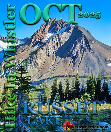
![]() Russet Lake is a surreal little paradise that lays at the base of The Fissile, in Garibaldi Provincial Park. The Fissile is the strikingly bronze mountain visible from Whistler Village. From the Village look into the distance at the Peak2Peak Gondola hanging between Whistler Mountain and Blackcomb Mountain and you will see The Fissile. Its pyramid shape in the distance perfectly separates the two mountains. Though Russet Lake is not terribly impressive in terms of size or colour, the valley around it is remarkably beautiful. The colours of everything around Russet Lake seem to change from moment to moment in and extraordinary way. The distinctive colour of The Fissile and the stark grey of the mountains around contrast amazingly with the blue of the lake and green grass in the valley. So many different factors fill the place with colour. There are several ways to get to hike Russet Lake. The Singing Pass trail from the base of Whistler Mountain near the Whistler Gondola. The Musical Bumps trail that begins near the top of the Whistler Gondola near the Roundhouse Lodge. Both routes take you deep into the magnificent Fitzsimmons Range. The Fitzsimmons Range runs east from the summit of Whistler Mountain to Russet Lake. Fitzsimmons Creek cuts between Whistler Mountain and Blackcomb Mountain, parallel to the Singing Pass trail. Where the Fitzsimmons Range ends at Fitzsimmons Creek, the Spearhead Range begins and continues along a set of peaks resembling spearheads to Blackcomb Mountain. These peaks include The Spearhead, Mount Trorey, Tremor, Shatter, Shudder, Quiver, and more.
Russet Lake is a surreal little paradise that lays at the base of The Fissile, in Garibaldi Provincial Park. The Fissile is the strikingly bronze mountain visible from Whistler Village. From the Village look into the distance at the Peak2Peak Gondola hanging between Whistler Mountain and Blackcomb Mountain and you will see The Fissile. Its pyramid shape in the distance perfectly separates the two mountains. Though Russet Lake is not terribly impressive in terms of size or colour, the valley around it is remarkably beautiful. The colours of everything around Russet Lake seem to change from moment to moment in and extraordinary way. The distinctive colour of The Fissile and the stark grey of the mountains around contrast amazingly with the blue of the lake and green grass in the valley. So many different factors fill the place with colour. There are several ways to get to hike Russet Lake. The Singing Pass trail from the base of Whistler Mountain near the Whistler Gondola. The Musical Bumps trail that begins near the top of the Whistler Gondola near the Roundhouse Lodge. Both routes take you deep into the magnificent Fitzsimmons Range. The Fitzsimmons Range runs east from the summit of Whistler Mountain to Russet Lake. Fitzsimmons Creek cuts between Whistler Mountain and Blackcomb Mountain, parallel to the Singing Pass trail. Where the Fitzsimmons Range ends at Fitzsimmons Creek, the Spearhead Range begins and continues along a set of peaks resembling spearheads to Blackcomb Mountain. These peaks include The Spearhead, Mount Trorey, Tremor, Shatter, Shudder, Quiver, and more.


Panorama Ridge - Best Whistler Aerial Views
![]() Panorama Ridge is easily one of the most amazing hikes in Garibaldi Provincial Park. The 15 kilometre hike from the trailhead at Rubble Creek to Panorama Ridge takes you through beautiful and deep forests, across countless idyllic streams, through meadows filled with flowers, and past dozens of jaw dropping viewpoints. The amazing views start once you reach Taylor Meadows and get even more spectacular as the trail progresses. Once you arrive at Panorama Ridge and its phenomenal vantage point, high above Garibaldi Park, you will stare in wonder. The hiking options around and beyond Panorama Ridge are quite good. Most hike to Garibaldi Lake to camp on the way to Panorama Ridge. Taylor Meadows is another route to Panorama Ridge and another campground. If you are hiking in a day, you can hike Rubble Creek to Taylor Meadows, then Panorama Ridge, returning via Garibaldi Lake. Garibaldi Lake barely adds any hiking distance to the overall journey with just a couple extra kilometres. Black Tusk is found on the way to Panorama Ridge and Helm Creek and Cheakamus Lake are found beyond, if hiking from the Rubble Creek side. Added to this you will find a wealth of alpine terrain leading to various mountain peaks and even the wonderful Helm Glacier. Panorama Ridge can be reached from the Garibaldi Lake(Rubble Creek) trailhead or the Cheakamus Lake trailhead. It is hard to say which is better. Rubble Creek is preferable if you are keen to stop at the beautiful Garibaldi Lake on the way. Certainly wonderful for a swim if you can take the glacial cold water. The Cheakamus Lake trailhead is similarly scenic minus the beautiful lake, but it is incredibly free of people. If you seek serenity, this is the way. Certainly, if you plan to overnight, this is the better way as well. The Taylor Meadows campground (Rubble Creek side) is often overrun on the weekends, while Helm Creek(Cheakamus Lake side) is not.
Panorama Ridge is easily one of the most amazing hikes in Garibaldi Provincial Park. The 15 kilometre hike from the trailhead at Rubble Creek to Panorama Ridge takes you through beautiful and deep forests, across countless idyllic streams, through meadows filled with flowers, and past dozens of jaw dropping viewpoints. The amazing views start once you reach Taylor Meadows and get even more spectacular as the trail progresses. Once you arrive at Panorama Ridge and its phenomenal vantage point, high above Garibaldi Park, you will stare in wonder. The hiking options around and beyond Panorama Ridge are quite good. Most hike to Garibaldi Lake to camp on the way to Panorama Ridge. Taylor Meadows is another route to Panorama Ridge and another campground. If you are hiking in a day, you can hike Rubble Creek to Taylor Meadows, then Panorama Ridge, returning via Garibaldi Lake. Garibaldi Lake barely adds any hiking distance to the overall journey with just a couple extra kilometres. Black Tusk is found on the way to Panorama Ridge and Helm Creek and Cheakamus Lake are found beyond, if hiking from the Rubble Creek side. Added to this you will find a wealth of alpine terrain leading to various mountain peaks and even the wonderful Helm Glacier. Panorama Ridge can be reached from the Garibaldi Lake(Rubble Creek) trailhead or the Cheakamus Lake trailhead. It is hard to say which is better. Rubble Creek is preferable if you are keen to stop at the beautiful Garibaldi Lake on the way. Certainly wonderful for a swim if you can take the glacial cold water. The Cheakamus Lake trailhead is similarly scenic minus the beautiful lake, but it is incredibly free of people. If you seek serenity, this is the way. Certainly, if you plan to overnight, this is the better way as well. The Taylor Meadows campground (Rubble Creek side) is often overrun on the weekends, while Helm Creek(Cheakamus Lake side) is not.


Parkhurst - Best Whistler Aerial Views
![]() Whistler has an absurd number of wonderful and free hiking trails and Parkhurst Ghost Town certainly ranks as one of the most unusual, exotic and interesting. Parkhurst was a little logging town perched on the edge of Green Lake way before Whistler was Whistler. Up on the ridge where Parkhurst sits, the views are sensational. Green Lake far below, a solid unnatural looking mass of green. Blackcomb Mountain and Whistler Mountain out in the distance to the left and Rainbow Mountain across and beyond the lake. As recent as the late 90's a few houses remained standing, but the merciless winters with crushing snow has collapsed all but one house. There are a couple half collapsed relics, but for the most part the town has disintegrated. Unexpectedly, even in the deep snow of winter, stumbling on remnants of the old town are frequent. Countless half collapsed houses lay in the picturesque forest that has grown since the town was abandoned. Finding the abandoned vehicles in the town is like a game as you wander around the maze of trails. The old rusty car, the even older truck, and an ancient and enormous logging tractor perched as it was decades ago, on the edge of Green Lake. Quite a marvel to see. Like a giant museum exhibit that looks like it could still be there in a thousand years from now.
Whistler has an absurd number of wonderful and free hiking trails and Parkhurst Ghost Town certainly ranks as one of the most unusual, exotic and interesting. Parkhurst was a little logging town perched on the edge of Green Lake way before Whistler was Whistler. Up on the ridge where Parkhurst sits, the views are sensational. Green Lake far below, a solid unnatural looking mass of green. Blackcomb Mountain and Whistler Mountain out in the distance to the left and Rainbow Mountain across and beyond the lake. As recent as the late 90's a few houses remained standing, but the merciless winters with crushing snow has collapsed all but one house. There are a couple half collapsed relics, but for the most part the town has disintegrated. Unexpectedly, even in the deep snow of winter, stumbling on remnants of the old town are frequent. Countless half collapsed houses lay in the picturesque forest that has grown since the town was abandoned. Finding the abandoned vehicles in the town is like a game as you wander around the maze of trails. The old rusty car, the even older truck, and an ancient and enormous logging tractor perched as it was decades ago, on the edge of Green Lake. Quite a marvel to see. Like a giant museum exhibit that looks like it could still be there in a thousand years from now.


Blackcomb Mountain - Best Whistler Aerial Views
![]() Blackcomb Mountain is much less known for its hiking trails than Whistler Mountain. It is hard to compare the two mountains hiking trails as they are so different and beautiful in their own set of ways. Whistler Mountain trails look down on Cheakamus Lake and the Whistler Valley, whereas the Blackcomb Mountain trails mostly face across the valley toward Whistler Mountain. Cheakamus Lake is stunning with its extraordinarily brilliant colour, while Blackcomb's view of Whistler Mountain is magnificent. Three aspects of the Blackcomb Mountain trails make it truly wonderful. First, the trail itself takes you through truck sized boulders and weather brutalized krummholz trees. Often you find yourself marvelling at the trail bending around enormous erratics that appear to have been placed their out of nowhere. Short, thick, mangled looking trees grow in the most improbable places. Between giant boulders or on ground that appears to be solid rock. The second astoundingly beautiful feature of the Blackcomb Mountain trails appears quite suddenly along the Overlord trail, when Overlord Glacier, Overlord Mountain and The Fissile come into view all at once.
Blackcomb Mountain is much less known for its hiking trails than Whistler Mountain. It is hard to compare the two mountains hiking trails as they are so different and beautiful in their own set of ways. Whistler Mountain trails look down on Cheakamus Lake and the Whistler Valley, whereas the Blackcomb Mountain trails mostly face across the valley toward Whistler Mountain. Cheakamus Lake is stunning with its extraordinarily brilliant colour, while Blackcomb's view of Whistler Mountain is magnificent. Three aspects of the Blackcomb Mountain trails make it truly wonderful. First, the trail itself takes you through truck sized boulders and weather brutalized krummholz trees. Often you find yourself marvelling at the trail bending around enormous erratics that appear to have been placed their out of nowhere. Short, thick, mangled looking trees grow in the most improbable places. Between giant boulders or on ground that appears to be solid rock. The second astoundingly beautiful feature of the Blackcomb Mountain trails appears quite suddenly along the Overlord trail, when Overlord Glacier, Overlord Mountain and The Fissile come into view all at once.


Whistler Mountain - Best Whistler Aerial Views
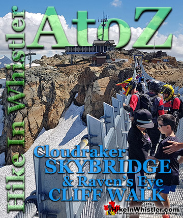
![]() The alpine hiking trails on Whistler Mountain are the ultimate in luxurious, quick-access alpine hiking. Little effort gets you amazing views of turquoise lakes, snowy mountains, valleys of flowers and distant glaciers. The Whistler Gondola takes you to the Roundhouse Lodge where you find gift shops, restaurants, viewing decks and the new Umbrella Bar. Just steps from the Roundhouse Lodge is one end of the Peak2Peak Gondola which takes you across to Blackcomb Mountain and another nice array of beautiful hiking trails. In the summer months, Whistler Mountain is somewhat divided in two. The lower half of the mountain is for biking and the upper half is more for hiking, sightseeing, trail running, eating and drinking. There are three main directions you can hike from the Roundhouse Lodge. Just past the Peak2Peak Gondola building you will see the Spearhead Loop trail that is 1.2 kilometres or 0.7 miles long and with not a lot of elevation gain/loss at roughly 20 metres or 66 feet overall. Following it to the left you will descend down an easy trail toward Harmony Lake where you can link to the Harmony Lake Loop trail or veer back to where you started. If you follow the Spearhead Loop trail to the right you will quickly ascend a gravel road and after a couple hundred metres find the junction to Pika’s Traverse Road. This gravel access road takes you up to the summit of Whistler Mountain via a constantly ascending, though very beautiful 3.2 kilometre or 2 mile route. New in 2018 the Cloudraker Skybridge was built spanning the gap between cliffs just steps from the top of the Peak Express Chair. At 130 metres long and with Whistler Bowl directly below, the bridge sways as you walk across the dizzyingly high gap to the new Raven's Eye Cliff Walk. The Raven's Eye Cliff Walk gives you wonderful views over the Whistler valley as well as an excellent vantage point to see the Peak Express Chair with Blackcomb Mountain and the Spearhead Range in the background.
The alpine hiking trails on Whistler Mountain are the ultimate in luxurious, quick-access alpine hiking. Little effort gets you amazing views of turquoise lakes, snowy mountains, valleys of flowers and distant glaciers. The Whistler Gondola takes you to the Roundhouse Lodge where you find gift shops, restaurants, viewing decks and the new Umbrella Bar. Just steps from the Roundhouse Lodge is one end of the Peak2Peak Gondola which takes you across to Blackcomb Mountain and another nice array of beautiful hiking trails. In the summer months, Whistler Mountain is somewhat divided in two. The lower half of the mountain is for biking and the upper half is more for hiking, sightseeing, trail running, eating and drinking. There are three main directions you can hike from the Roundhouse Lodge. Just past the Peak2Peak Gondola building you will see the Spearhead Loop trail that is 1.2 kilometres or 0.7 miles long and with not a lot of elevation gain/loss at roughly 20 metres or 66 feet overall. Following it to the left you will descend down an easy trail toward Harmony Lake where you can link to the Harmony Lake Loop trail or veer back to where you started. If you follow the Spearhead Loop trail to the right you will quickly ascend a gravel road and after a couple hundred metres find the junction to Pika’s Traverse Road. This gravel access road takes you up to the summit of Whistler Mountain via a constantly ascending, though very beautiful 3.2 kilometre or 2 mile route. New in 2018 the Cloudraker Skybridge was built spanning the gap between cliffs just steps from the top of the Peak Express Chair. At 130 metres long and with Whistler Bowl directly below, the bridge sways as you walk across the dizzyingly high gap to the new Raven's Eye Cliff Walk. The Raven's Eye Cliff Walk gives you wonderful views over the Whistler valley as well as an excellent vantage point to see the Peak Express Chair with Blackcomb Mountain and the Spearhead Range in the background.


Brandywine Falls - Best Whistler Aerial Views
![]() Brandywine Falls Provincial Park is a very convenient stop along the Sea to Sky Highway on the way to or from Whistler. The falls spill over an abrupt 66 metre cliff with a perfectly positioned viewing platform to view it. Most just take the short, 5 minute hiking trail to the viewing area, however Brandywine Falls Provincial Park has a couple connecting trails to cute little lakes as well as the wonderful Sea to Sky Trail. The Sea to Sky Trail is a wide, gravel, dirt or paved trail that connects to Whistler Village almost entirely away from humanity. Brandywine Falls Provincial Park is wonderful for so many reasons. First it is dramatically beautiful as it plunges from an abrupt cliff. Second it is very easy to get to and easy to hike to. The viewing areas are nicely located and the far viewing area overlooks the massive valley toward Daisy Lake.
Brandywine Falls Provincial Park is a very convenient stop along the Sea to Sky Highway on the way to or from Whistler. The falls spill over an abrupt 66 metre cliff with a perfectly positioned viewing platform to view it. Most just take the short, 5 minute hiking trail to the viewing area, however Brandywine Falls Provincial Park has a couple connecting trails to cute little lakes as well as the wonderful Sea to Sky Trail. The Sea to Sky Trail is a wide, gravel, dirt or paved trail that connects to Whistler Village almost entirely away from humanity. Brandywine Falls Provincial Park is wonderful for so many reasons. First it is dramatically beautiful as it plunges from an abrupt cliff. Second it is very easy to get to and easy to hike to. The viewing areas are nicely located and the far viewing area overlooks the massive valley toward Daisy Lake.


Logger's Lake - Best Whistler Aerial Views
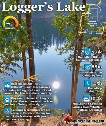
![]() Logger’s Lake is an amazing little lake hidden up in the deep forest above the more well known Cheakamus River. The lake, almost unbelievably exists in a long extinct volcano. However, as soon as you see the lake up close, you quickly come to believe it. The lake sits in a beautifully volcano-shaped bowl, with one side of the bowl a crumbling array of huge, cube shaped boulders leading down to, and spilling into the lake. The crater that Logger’s Lake sits in was a volcano that pushed through the glacial ice in this valley about 10000 years ago. As the lava cooled it formed the wonderful basalt ridge that is crumbling into valley. As Logger’s Lake sits deep in this ancient volcano's vent, it is sheltered from the wind and soaks up the suns rays into the dark boulders all around. As a result makes it the warmest lake in Whistler, though most other lakes around are glacier fed(via rivers and creeks), so the comparison is not entirely fair. The surrounding cliffs and forest also add to the tranquility of the lake. Located a bit off the radar for most and requiring a short logging road drive and then a very steep, but short hike to get to also contributes to its serenity.
Logger’s Lake is an amazing little lake hidden up in the deep forest above the more well known Cheakamus River. The lake, almost unbelievably exists in a long extinct volcano. However, as soon as you see the lake up close, you quickly come to believe it. The lake sits in a beautifully volcano-shaped bowl, with one side of the bowl a crumbling array of huge, cube shaped boulders leading down to, and spilling into the lake. The crater that Logger’s Lake sits in was a volcano that pushed through the glacial ice in this valley about 10000 years ago. As the lava cooled it formed the wonderful basalt ridge that is crumbling into valley. As Logger’s Lake sits deep in this ancient volcano's vent, it is sheltered from the wind and soaks up the suns rays into the dark boulders all around. As a result makes it the warmest lake in Whistler, though most other lakes around are glacier fed(via rivers and creeks), so the comparison is not entirely fair. The surrounding cliffs and forest also add to the tranquility of the lake. Located a bit off the radar for most and requiring a short logging road drive and then a very steep, but short hike to get to also contributes to its serenity.


Sproatt - Best Whistler Aerial Views
![]() Mount Sproatt, or as it is known locally as just Sproatt, is one of the many towering mountains visible from Whistler Village. Above and beyond Alta Lake, directly across from Whistler Mountain and Blackcomb Mountain, you will see this quiet giant. Its unremarkable appearance hides the growing network of trails that stretch through some startlingly beautiful terrain. Truck sized erratics in the midst of vibrant green meadows, mountain lakes everywhere you look, and endless open alpine terrain. Mount Sproatt is largely off the radar for most hikers. It doesn't have dramatically beautiful views like you get at Panorama Ridge, Black Tusk, Cheakamus Lake, Garibaldi Lake or Wedgemount Lake. On Sproatt you get a hostile, winter battered alpine that has the wonderful feeling of being unexplored. You can wander in many directions and guess at what you will find. A spectacular little mountain lake, a breathtaking view of Hanging Lake, Sproatt Lake, Alta Lake, Whistler Mountain, Blackcomb Mountain, Rainbow Mountain and quite a lot more. Most trails on Sproatt were built as bike trails and the vast majority of traffic is therefore bikes. If you are biking Sproatt, you generally follow the trails closely and move quickly. If you are hiking Sproatt, you tend to veer off the trails and quickly find yourself on a seemingly deserted alpine paradise. There are many small mountain peaks and some larger ones. Gin Peak and Tonic Peak are two of the larger ones you will encounter and there are dozens of smaller ones. Each is a little world of its own and almost always a world to yourself.
Mount Sproatt, or as it is known locally as just Sproatt, is one of the many towering mountains visible from Whistler Village. Above and beyond Alta Lake, directly across from Whistler Mountain and Blackcomb Mountain, you will see this quiet giant. Its unremarkable appearance hides the growing network of trails that stretch through some startlingly beautiful terrain. Truck sized erratics in the midst of vibrant green meadows, mountain lakes everywhere you look, and endless open alpine terrain. Mount Sproatt is largely off the radar for most hikers. It doesn't have dramatically beautiful views like you get at Panorama Ridge, Black Tusk, Cheakamus Lake, Garibaldi Lake or Wedgemount Lake. On Sproatt you get a hostile, winter battered alpine that has the wonderful feeling of being unexplored. You can wander in many directions and guess at what you will find. A spectacular little mountain lake, a breathtaking view of Hanging Lake, Sproatt Lake, Alta Lake, Whistler Mountain, Blackcomb Mountain, Rainbow Mountain and quite a lot more. Most trails on Sproatt were built as bike trails and the vast majority of traffic is therefore bikes. If you are biking Sproatt, you generally follow the trails closely and move quickly. If you are hiking Sproatt, you tend to veer off the trails and quickly find yourself on a seemingly deserted alpine paradise. There are many small mountain peaks and some larger ones. Gin Peak and Tonic Peak are two of the larger ones you will encounter and there are dozens of smaller ones. Each is a little world of its own and almost always a world to yourself.


Joffre Lakes - Best Whistler Aerial Views
![]() Joffre Lakes Provincial Park is a gorgeous park with extraordinarily coloured lakes, waterfalls, stunning mountain peaks and ominous glaciers pouring into the valley. Joffre Lakes is one of those incredible places that makes it hard to take a boring picture. The three Joffre Lakes are some of the most stunning lakes you are likely to ever see. Each lake gets progressively more beautiful and impossibly turquoise from one to the next. By the third lake the intense colour is breathtaking. The mighty Matier Glacier rises above and beyond the third lake, making the experience even more spectacular with such a looming presence. Located an hours drive north of Whistler in the vast wilderness of mountains split by the Duffy Lake Road. Expect to take an hour to drive the 61 kilometres to the trailhead. There are three lakes in Joffre Lakes Provincial Park and all of them beautiful on their own. The first lake, Lower Joffre Lake is just steps from the parking lot/trailhead and the views are already fantastic. It has a wonderful turquoise colour that comes from light reflecting off particles of rock suspended in the glacier meltwater. The lake is surrounded by pristine wilderness of uniformly idyllic trees. Looking across the lake, two mountains frame a distant glacier, which looks strangely close and ominously huge. It is the Matier Glacier which fills the steep valley above the third of the Joffre Lakes, Upper Joffre Lake, and marks the end of the trail that you just started. Partway between Lower Joffre Lake and Upper Joffre Lake is Middle Joffre Lake. More details, directions and maps for Joffre Lakes.
Joffre Lakes Provincial Park is a gorgeous park with extraordinarily coloured lakes, waterfalls, stunning mountain peaks and ominous glaciers pouring into the valley. Joffre Lakes is one of those incredible places that makes it hard to take a boring picture. The three Joffre Lakes are some of the most stunning lakes you are likely to ever see. Each lake gets progressively more beautiful and impossibly turquoise from one to the next. By the third lake the intense colour is breathtaking. The mighty Matier Glacier rises above and beyond the third lake, making the experience even more spectacular with such a looming presence. Located an hours drive north of Whistler in the vast wilderness of mountains split by the Duffy Lake Road. Expect to take an hour to drive the 61 kilometres to the trailhead. There are three lakes in Joffre Lakes Provincial Park and all of them beautiful on their own. The first lake, Lower Joffre Lake is just steps from the parking lot/trailhead and the views are already fantastic. It has a wonderful turquoise colour that comes from light reflecting off particles of rock suspended in the glacier meltwater. The lake is surrounded by pristine wilderness of uniformly idyllic trees. Looking across the lake, two mountains frame a distant glacier, which looks strangely close and ominously huge. It is the Matier Glacier which fills the steep valley above the third of the Joffre Lakes, Upper Joffre Lake, and marks the end of the trail that you just started. Partway between Lower Joffre Lake and Upper Joffre Lake is Middle Joffre Lake. More details, directions and maps for Joffre Lakes.


Rainbow Lake - Best Whistler Aerial Views
![]() The Rainbow Trail is a convenient and popular trail near Whistler Village that takes you to Rainbow Lake as well as the Rainbow-Sproatt Flank Trail, Rainbow Falls, Hanging Lake, Madeley Lake, Beverley Lake, Rainbow Mountain... and even Whistler Olympic Park if you are determined. It is a consistently uphill and very beautiful trail with several water (bridge) crossings and waterfalls on the way to the picture-perfect lake. There are a few views of the valley across to Whistler Mountain, Blackcomb Mountain, and Wedge Mountain. Rainbow Lake itself is in a gorgeous alpine valley with branching trails that extend further beyond the lake in at least three directions. Along with the waterfalls, bridge crossings and valley views, the Rainbow Trail passes through deep forest with some impressively huge trees. Plenty of birds can be heard and seen along the trail and though black bears frequent the area, they are infrequently spotted due to their migration down into the valley.
The Rainbow Trail is a convenient and popular trail near Whistler Village that takes you to Rainbow Lake as well as the Rainbow-Sproatt Flank Trail, Rainbow Falls, Hanging Lake, Madeley Lake, Beverley Lake, Rainbow Mountain... and even Whistler Olympic Park if you are determined. It is a consistently uphill and very beautiful trail with several water (bridge) crossings and waterfalls on the way to the picture-perfect lake. There are a few views of the valley across to Whistler Mountain, Blackcomb Mountain, and Wedge Mountain. Rainbow Lake itself is in a gorgeous alpine valley with branching trails that extend further beyond the lake in at least three directions. Along with the waterfalls, bridge crossings and valley views, the Rainbow Trail passes through deep forest with some impressively huge trees. Plenty of birds can be heard and seen along the trail and though black bears frequent the area, they are infrequently spotted due to their migration down into the valley.


Alexander Falls - Best Whistler Aerial Views
![]() Alexander Falls is located far up in the Callaghan Valley just before the turnoff to Callaghan Lake Provincial Park. The falls are very impressive with its 43 metre or 141 foot drop into the boulder filled chasm below. A beautiful viewing area directly across from the falls gives you a great view and several picnic tables entice you to have a picnic. There are no hiking trails in Alexander Falls Provincial Park and it consists of a large parking lot with information boards, picnic tables, outhouses and a viewing platform. In the months preparing for the 2010 Olympic Games in Whistler the old Callaghan Valley Road was paved to the newly constructed Whistler Olympic Park just past Alexander Falls. The park, after the Olympics remained and is now a tourist attraction with the enormous ski jumps and sightseeing. The entry gate is just past the top of Alexander Falls and you can only access the Olympic Park when it is open during the summer and winter months. The once bumpy and potholed gravel road up the Callaghan Valley is now paved and quite a beautiful drive from Whistler Village. Expect to take about 40 minutes to reach Alexander Falls from Whistler Village. Along with the beautiful scenic drive to the falls you will often spot black bears alongside the road in the summer months. Nearby Madeley Lake and Callaghan Lake are both in the area and well worth a visit in the summer when the roads are free of snow.
Alexander Falls is located far up in the Callaghan Valley just before the turnoff to Callaghan Lake Provincial Park. The falls are very impressive with its 43 metre or 141 foot drop into the boulder filled chasm below. A beautiful viewing area directly across from the falls gives you a great view and several picnic tables entice you to have a picnic. There are no hiking trails in Alexander Falls Provincial Park and it consists of a large parking lot with information boards, picnic tables, outhouses and a viewing platform. In the months preparing for the 2010 Olympic Games in Whistler the old Callaghan Valley Road was paved to the newly constructed Whistler Olympic Park just past Alexander Falls. The park, after the Olympics remained and is now a tourist attraction with the enormous ski jumps and sightseeing. The entry gate is just past the top of Alexander Falls and you can only access the Olympic Park when it is open during the summer and winter months. The once bumpy and potholed gravel road up the Callaghan Valley is now paved and quite a beautiful drive from Whistler Village. Expect to take about 40 minutes to reach Alexander Falls from Whistler Village. Along with the beautiful scenic drive to the falls you will often spot black bears alongside the road in the summer months. Nearby Madeley Lake and Callaghan Lake are both in the area and well worth a visit in the summer when the roads are free of snow.


Complete Guide to Alexander Falls Provincial Park
Whistler Train Wreck - Best Whistler Aerial Views
![]() Whistler Train Wreck is an amazing, easy and accessible year-round hike in Whistler. The trail to Whistler Train Wreck is an easy, yet varied route through deep forest, across a great suspension bridge over Cheakamus River, to a stunning array of wrecked train cars. The trail from your car to the wrecks only takes about 15 minutes, however once you reach one wreck, you see another, then another. There are seven wrecks in total that are spread over an area about 400 metres long. Along with the surreal train wrecks painted with stunning murals, you find yourself in a thick forest that runs along Cheakamus River. Cheakamus River is a beautiful, wild and crashing river that snakes past the train wrecks. Numerous side trails take you to some marvellous viewpoints, several metres above the rushing water below. If you follow a trail past the wrecks(heading north or in the direction of Whistler Village) you will emerge at the train tracks. If you are adventurous you will then walk along, beside the tracks for a couple hundred metres and some truly incredible views of Cheakamus River.
Whistler Train Wreck is an amazing, easy and accessible year-round hike in Whistler. The trail to Whistler Train Wreck is an easy, yet varied route through deep forest, across a great suspension bridge over Cheakamus River, to a stunning array of wrecked train cars. The trail from your car to the wrecks only takes about 15 minutes, however once you reach one wreck, you see another, then another. There are seven wrecks in total that are spread over an area about 400 metres long. Along with the surreal train wrecks painted with stunning murals, you find yourself in a thick forest that runs along Cheakamus River. Cheakamus River is a beautiful, wild and crashing river that snakes past the train wrecks. Numerous side trails take you to some marvellous viewpoints, several metres above the rushing water below. If you follow a trail past the wrecks(heading north or in the direction of Whistler Village) you will emerge at the train tracks. If you are adventurous you will then walk along, beside the tracks for a couple hundred metres and some truly incredible views of Cheakamus River.


Complete Guide for Whistler Train Wreck
The Best Whistler & Garibaldi Park Hiking Trails!

Whistler & Garibaldi Park Hiking Glossary A to Z
Whistler & Garibaldi Park Best Hiking by Month!

Explore BC Hiking Destinations!
Whistler Hiking Trails
Squamish Hiking Trails
Vancouver Hiking Trails
Clayoquot Hiking Trails
Victoria Hiking Trails