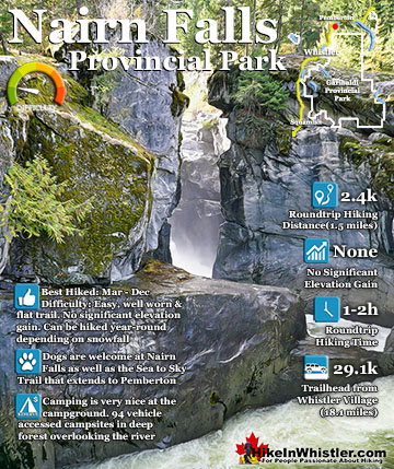
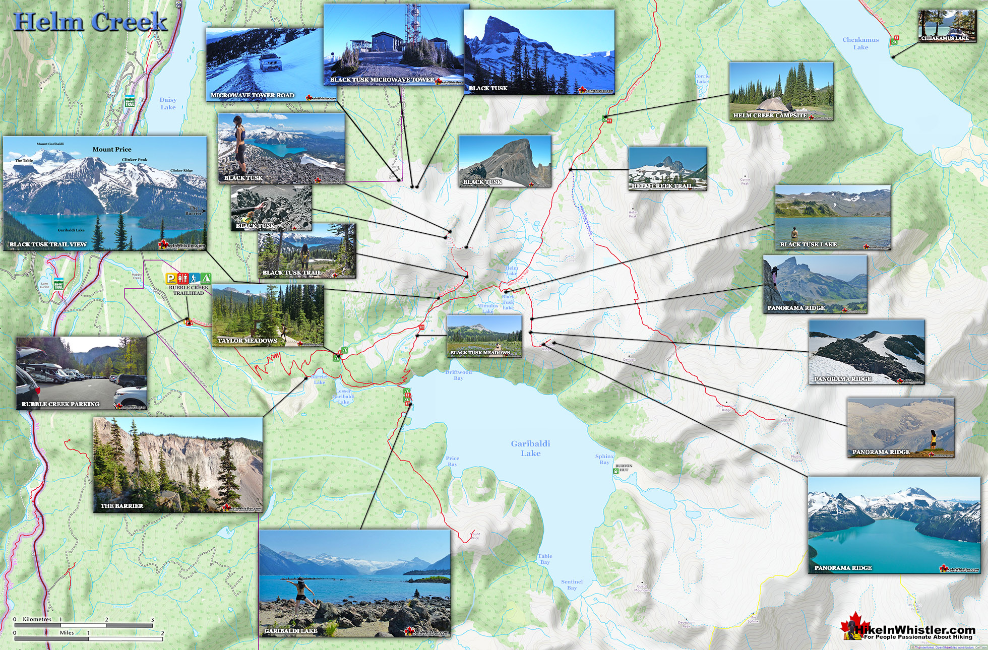
HikeInWhistler.com

HikeInWhistler.com

Menu
  • Hike
      • Alexander Falls Provincial Park
      • Ancient Cedars & Showh Lakes
      • Black Tusk in Garibaldi Park
      • Blackcomb Mountain Hiking Trails
      • Brandywine Falls Provincial Park
      • Brandywine Meadows
      • Brew Lake & Mount Brew
      • Callaghan Lake Park
      • Cheakamus Lake in Garibaldi Park
      • Cheakamus River & Interpretive Forest
      • Cirque Lake in Callaghan Valley
      • Flank Trail (Rainbow-Sproatt)
      • Garibaldi Lake in Garibaldi Park
      • Helm Creek in Garibaldi Park
      • Jane Lakes West
      • Joffre Lakes Provincial Park
      • Keyhole Hot Springs
      • Logger's Lake
      • Madeley Lake & Hanging Lake
      • Meager Hot Springs
      • Nairn Falls Provincial Park
      • Newt Lake & Ancient Cedars
      • Panorama Ridge in Garibaldi Park
      • Parkhurst Ghost Town
      • Rainbow Falls
      • Rainbow Lake
      • Ring Lake & Conflict Lake
      • Russet Lake in Garibaldi Park
      • Sea to Sky Trail
      • Skookumchuck Hot Springs
      • Sloquet Hot Springs
      • Sproatt West(Northair) Trail
      • Sproatt East(Stonebridge) Trail
      • Train Wreck & Trash Trail
      • Taylor Meadows in Garibaldi Park
      • Wedgemount Lake in Garibaldi Park
      • Whistler Mountain Hiking Trails
  • Snow
      • Blueberry Trail Snowshoeing
      • Brandywine Falls Snowshoeing
      • Cheakamus River Snowshoeing
      • Elfin Lakes Snowshoeing
      • Flank Trail Snowshoeing
      • Joffre Lakes Snowshoeing
      • Nairn Falls Snowshoeing
      • Parkhurst Ghost Town Snowshoeing
      • Rainbow Falls Snowshoeing
      • Rainbow Lake Snowshoeing
      • Rainbow Park Snowshoeing
      • Sproatt East Snowshoeing
      • Taylor Meadows Snowshoeing
      • Train Wreck Snowshoeing
      • Wedgemount Lake Snowshoeing
  • Run
      • Whistler Golf Course 5k(3.1 Mile)
      • Blueberry Hill 6k(3.7 Mile)
      • Lost Lake 6k(3.7 Mile)
      • Alta Lake 8k(5 Mile)
      • Fitzsimmons Creek 9k(5.6 Mile)
      • Alta Green Lost 15k(9.3 Mile)
  • Best
      • Best Whistler Hiking by Month
          • Best by Month
      • Best Walk, Bike or Bus To Trails
      • Best Whistler Kid Friendly Trails
      • Best Whistler Dog Friendly Trails
      • Best Free Camping in Whistler
      • Best Sights Sea to Sky
      • Best Whistler Waterfalls
      • Best Whistler Aerial Views
      • Best Squamish Hiking Trails
      • Best Whistler Hiking Trails
      • Best Vancouver Hiking Trails
      • Best Whistler Snowshoeing
          • Best Whistler Snowshoe Trails
      • Best Whistler Running Trails
      • Best Whistler Hiking Gear Rentals
      • Best Whistler Parks & Beaches
  • AtoZ
      • Ablation Zone
      • Accumulation Zone
      • Adit Lakes
      • Aiguille
      • Alpine Zone
      • Arborlith or Lithophyte
      • Arête
      • A River Runs Through It
      • Armchair Glacier
      • The Barrier
      • Battleship Islands
      • Bears
      • Bench
      • Bergschrund or Schrund
      • Bivouac or Bivy
      • Blue Face House in Parkhurst
      • Bungee Bridge
      • Cairns & Inukshuks
      • Carter, Neal
      • Caterpillar D8
      • Caterpillar RD8
      • Chimney
      • Cirque or Cirque Lake
      • Cloudraker Skybridge
      • Coast Mountains
      • Col
      • Crevasse
      • Deadfall
      • Emerald Forest
      • Erratic or Glacier Erratic
      • The Fissile
      • Fitzsimmons Creek
      • Fitzsimmons Range
      • Fyles, Tom
      • Garibaldi Ranges
      • Garibaldi Volcanic Belt
      • Gemel or Inosculation
      • Glacier Window
      • Green Lake
      • Hoary Marmot
      • Krummholz
      • Moraine
      • Mount Garibaldi
      • Mount James Turner
      • Northair Mine
      • Nunatuk
      • Overlord Mountain & Glacier
      • Peak2Peak Gondola
      • Roundhouse Lodge
      • Rubble Creek
      • Spearhead Range
      • Tarn
      • The Table
      • Usnea or Old Man's Beard
      • Western Redcedar
  • Maps
      • Alexander Falls Maps
      • Ancient Cedars Maps
      • Black Tusk Maps
      • Blackcomb Mountain Maps
      • Brandywine Falls Maps
      • Brandywine Meadows Maps
      • Brew Lake Maps
      • Callaghan Lake Maps
      • Cheakamus Lake Maps
      • Cheakamus River Maps
      • Cirque Lake Maps
      • Garibaldi Lake Maps
      • Helm Creek Maps
      • Joffre Lakes Maps
      • Keyhole Hot Springs Maps
      • Logger's Lake Maps
      • Madeley Lake Maps
      • Meager Hot Springs Maps
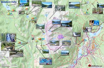
      • Nairn Falls Maps
      • Panorama Ridge Maps
      • Parkhurst Ghost Town Maps
      • Rainbow Falls Maps
      • Rainbow Lake Maps
      • Ring Lake Maps
      • Russet Lake Maps
      • Skookumchuck Maps
      • Sloquet Hot Springs Maps
      • Sproatt Maps
      • Taylor Meadows Maps
      • Train Wreck Maps
      • Wedgemount Lake Maps
      • Whistler Mountain Maps
  • More
      • Whistler Hiking News & Blog
      • Live Whistler Webcams
      • Live Tofino Webcams
      • Live Vancouver Webcams
      • Garibaldi Provincial Park
      • Hike in Whistler Glossary

Black Tusk

Wedgemount Lake

Brandywine Meadows

Cirque Lake

Adit Lakes

Whistler Train Wreck

Joffre Lakes

Newt Lake

Logger's Lake

Northair Mine

Callaghan Lake

Black Tusk

Wedgemount Lake

Spectacular Whistler!

Whistler hiking is wonderful! Check out our Best Whistler Hiking by Month guides! WeRentGear.com rents tents, sleeping bags, sleeping pads, camp stoves, packs, complete kits and more!

Best Trails This Week!

Best This Week: Whistler Train Wreck and Parkhurst Ghost Town are easy, fun and dog friendly. Check out our May and June Whistler and Garibaldi Park guides here!

Helm Creek is a cute, meandering creek that winds its way from beyond Black Tusk, down the valley to the wonderful campground that takes its name. From the Helm Creek campground, Helm Creek descends further along the Helm Creek trail, until it joins Cheakamus River, not far from where it leaves Cheakamus Lake. The location of Helm Creek campground is pretty amazing for a variety of reasons.

  • Spread out and serene campsite setting
  • Well organized campground in deep wilderness
  • Connects to Black Tusk via gorgeous ridge route
  • Very serene setting next to idyllic creek
  • Endless unmarked routes to amazing sights
  • Black Tusk looms beautifully very near
  • More of a crossroads than a destination
  • No glacier views like you get at Garibaldi Lake
  • No convenient lake to swim in
  • Fills up fast with just a few tent pads

First it is just a great location. About halfway between Cheakamus Lake and Black Tusk it lays in some amazingly scenic areas of Garibaldi Park. Beautiful, climbable mountains all around. Amazing fields of snow that run all the way to the base of Black Tusk well into July. Rivers, creeks and waterfalls everywhere you look from the idyllic campground. A large, grassy field ringed by trees and Helm Creek.  What you always want from a campground is a convenient and clean water source and of course Helm Creek is both.  Another aspect of a great campground is a variety of beautiful views and a serene setting and again Helm Creek has both of these.  The campground is so widespread that even if the area becomes busy, you can still manage to not hear your neighbours. This part of Garibaldi Park really has no defined trails except the Helm Creek trail that runs past the campsite, but there are infinitely numerous directions you can wander.  Exploring in any direction takes you to more and more pristine, green fields, streams, pocket lakes and mountain views.  Though most just use it as a base to extend onto Black Tusk, it is a great base for so much more. Helm Peak, Corrie Peak, Cinder Cone, Empetrum Peak as well as the more frequented Panorama Ridge, Black Tusk and Garibaldi Lake.

Helm Creek Campground

Possibly the nicest aspect of Helm Creek as a campground is that it is quiet and serene when compared with the other two area Garibaldi Park campgrounds. Garibaldi Lake and Taylor Meadows are very busy all summer long. At Helm Creek you find yourself in a remote and quiet valley in the midst of paradise. From the trail junction in the campground you see the enticing sign indicating what is around you. The nice, well marked trail continues to Panorama Ridge in 7 kilometres.  Black Tusk in 9.5 kilometres or Garibaldi Lake in 9 kilometres.  All of these destinations branch off the main trail that ascends away from Helm Creek.  Another popular, yet unmarked destination from Helm Creek is the Helm Glacier.  Though unmarked, it is very easy to find on the trail from Helm Creek that leads to Black Tusk, Panorama Ridge and Garibaldi Lake. Just keep your eyes out for the fantastic erratic, with the tree growing out of it along the trail.  It is obvious when you spot it(about 20 minutes from the Helm Creek campground).  At this marvellous display of glacier power and a hardy krummholz breaking apart this huge glacier deposited boulder, turn left and walk up the open valley and you will arrive at the amazing Helm Glacier in just 45 minutes.  In the opposite direction from Helm Creek from where you just came the sign shows Cheakamus Lake to be 8.5 kilometres away and the Cheakamus Lake trailhead and parking lot to be 8.5 kilometres away.  This trail slowly descends the valley for a couple kilometres before more steeply zig-zagging down to the Cheakamus River crossing.

Helm Creek Large Map v14a

Helm Creek Campground

Helm Creek Campground

Helm Creek Erratic

Black Tusk from Helm Creek Trail

Helm Creek Trail Directions Map

More hiking info for Helm Creek...

More Whistler & Garibaldi Park Hiking Maps!

Skookumchuck Hot Springs Maps

Skookumchuck Hot Springs(aka T'sek Hot Springs and St. Agnes Well), located two hours north of Whistler along the edge of the huge Lillooet River. The name Skookumchuck ...
Read more

Ancient Cedars Maps

Ancient Cedars is a nice, easy/moderate 2.6 kilometre(1.6 mile) hiking trail on the far side of Cougar Mountain, just 13.1 kilometres north of Whistler Village. A small, ...
Read more

Cirque Lake Maps

Cirque Lake is a wild and beautiful lake that hides high above and beyond Callaghan Lake in Callaghan Lake Provincial Park.  What makes Cirque Lake special among the other ...
Read more

Rainbow Falls Maps

The short, scenic and easy hiking trail to Rainbow Falls is located just a short, half kilometre from the Rainbow Lake or Rainbow Trail trailhead. The trail begins by ...
Read more
More Whistler Hiking Trail Maps

West Coast Trail Best Sights

Whistler & Garibaldi Park Glossary A to Z

Bench: a flat section in steep terrain.  Characteristically narrow, flat or gently sloping with steep or vertical slopes on either side.  A bench can be ...
Read more
The Garibaldi Ranges are a subdivision of the Pacific Ranges of the Coast Mountains.  Deriving its name from Mount Garibaldi, the Garibaldi Ranges cover the huge ...
Read more
The Peak 2 Peak Gondola connects Whistler Mountain and Blackcomb Mountain at a dizzying height of 436 metres(1427 feet).  It runs all winter and in the ...
Read more
Along the shore of Green Lake, you will find a monstrous old Caterpillar tractor that dates from the 1930’s.  Abandoned here in the 1950’s, it looks as if the ...
Read more
Inosculation is the technical name for two or more trees that have fused together into a single bizarre looking tree. They are colloquially known as ...
Read more
Western redcedar is a very large tree commonly found in the Pacific Northwest. Frequently growing up to 70 metres and with a trunk diameter of 7 metres, ...
Read more
The Fitzsimmons Range is a subsection of the Garibaldi Ranges that covers the area between the valleys of Cheakamus Lake and Fitzsimmons Creek.  Fitzsimmons ...
Read more
Back in 2011 Kups, a Whistler local and now professional muralist painted a hauntingly surreal, blue face on the side of this house.  This beautiful ...
Read more
More Hike in Whistler Glossary

Free Camping Gear Delivery to Garibaldi Park

The Best Whistler & Garibaldi Park Hiking Trails!

Ring Lake is a fantastically serene and wonderfully remote lake similar to Cirque Lake, but considerably farther to hike to reach it. The 10 kilometre(6.2 mile) hike takes you through a rarely hiked forest, ...
Read more
Mount Sproatt, or as it is known locally as just Sproatt, is one of the many towering mountains visible from Whistler Village. Above and beyond Alta Lake, directly across from Whistler Mountain and ...
Read more
Cheakamus Lake is a wonderfully relaxing way to get in the wilderness easily and quickly from Whistler Village. The trail begins on the far side of Whistler Mountain, 8 kilometres from the Sea to Sky Highway ...
Read more
Ancient Cedars is a nice, easy/moderate 2.5 kilometre (1.6 mile) hiking trail on the far side of Cougar Mountain, just 13.1 kilometres north of Whistler Village. A small, untouched grove of huge western ...
Read more
More Whistler Hiking Trails & Maps

HikeInWhistler.com HikeInWhistler.com © 2025
  • Contact Us: [email protected]