HikeInWhistler.com

HikeInWhistler.com

Menu
  • Hike
      • Alexander Falls Provincial Park
      • Ancient Cedars & Showh Lakes
      • Black Tusk in Garibaldi Park
      • Blackcomb Mountain Hiking Trails
      • Brandywine Falls Provincial Park
      • Brandywine Meadows
      • Brew Lake & Mount Brew
      • Callaghan Lake Park
      • Cheakamus Lake in Garibaldi Park
      • Cheakamus River & Interpretive Forest
      • Cirque Lake in Callaghan Valley
      • Flank Trail (Rainbow-Sproatt)
      • Garibaldi Lake in Garibaldi Park
      • Helm Creek in Garibaldi Park
      • Jane Lakes West
      • Joffre Lakes Provincial Park
      • Keyhole Hot Springs
      • Logger's Lake
      • Madeley Lake & Hanging Lake
      • Meager Hot Springs
      • Nairn Falls Provincial Park
      • Newt Lake & Ancient Cedars
      • Panorama Ridge in Garibaldi Park
      • Parkhurst Ghost Town
      • Rainbow Falls
      • Rainbow Lake
      • Ring Lake & Conflict Lake
      • Russet Lake in Garibaldi Park
      • Sea to Sky Trail
      • Skookumchuck Hot Springs
      • Sloquet Hot Springs
      • Sproatt West(Northair) Trail
      • Sproatt East(Stonebridge) Trail
      • Train Wreck & Trash Trail
      • Taylor Meadows in Garibaldi Park
      • Wedgemount Lake in Garibaldi Park
      • Whistler Mountain Hiking Trails
  • Snow
      • Blueberry Trail Snowshoeing
      • Brandywine Falls Snowshoeing
      • Cheakamus River Snowshoeing
      • Elfin Lakes Snowshoeing
      • Flank Trail Snowshoeing
      • Joffre Lakes Snowshoeing
      • Nairn Falls Snowshoeing
      • Parkhurst Ghost Town Snowshoeing
      • Rainbow Falls Snowshoeing
      • Rainbow Lake Snowshoeing
      • Rainbow Park Snowshoeing
      • Sproatt East Snowshoeing
      • Taylor Meadows Snowshoeing
      • Train Wreck Snowshoeing
      • Wedgemount Lake Snowshoeing
  • Run
      • Whistler Golf Course 5k(3.1 Mile)
      • Blueberry Hill 6k(3.7 Mile)
      • Lost Lake 6k(3.7 Mile)
      • Alta Lake 8k(5 Mile)
      • Fitzsimmons Creek 9k(5.6 Mile)
      • Alta Green Lost 15k(9.3 Mile)
  • Best
      • Best Whistler Hiking by Month
          • Best by Month
      • Best Walk, Bike or Bus To Trails
      • Best Whistler Kid Friendly Trails
      • Best Whistler Dog Friendly Trails
      • Best Free Camping in Whistler
      • Best Sights Sea to Sky
      • Best Whistler Waterfalls
      • Best Whistler Aerial Views
      • Best Squamish Hiking Trails
      • Best Whistler Hiking Trails
      • Best Vancouver Hiking Trails
      • Best Whistler Snowshoeing
          • Best Whistler Snowshoe Trails
      • Best Whistler Running Trails
      • Best Whistler Hiking Gear Rentals
      • Best Whistler Parks & Beaches
  • AtoZ
      • Ablation Zone
      • Accumulation Zone
      • Adit Lakes
      • Aiguille
      • Alpine Zone
      • Arborlith or Lithophyte
      • Arête
      • A River Runs Through It
      • Armchair Glacier
      • The Barrier
      • Battleship Islands
      • Bears
      • Bench
      • Bergschrund or Schrund
      • Bivouac or Bivy
      • Blue Face House in Parkhurst
      • Bungee Bridge
      • Cairns & Inukshuks
      • Carter, Neal
      • Caterpillar D8
      • Caterpillar RD8
      • Chimney
      • Cirque or Cirque Lake
      • Cloudraker Skybridge
      • Coast Mountains
      • Col
      • Crevasse
      • Deadfall
      • Emerald Forest
      • Erratic or Glacier Erratic
      • The Fissile
      • Fitzsimmons Creek
      • Fitzsimmons Range
      • Fyles, Tom
      • Garibaldi Ranges
      • Garibaldi Volcanic Belt
      • Gemel or Inosculation
      • Glacier Window
      • Green Lake
      • Hoary Marmot
      • Krummholz
      • Moraine
      • Mount Garibaldi
      • Mount James Turner
      • Northair Mine
      • Nunatuk
      • Overlord Mountain & Glacier
      • Peak2Peak Gondola
      • Roundhouse Lodge
      • Rubble Creek
      • Spearhead Range
      • Tarn
      • The Table
      • Usnea or Old Man's Beard
      • Western Redcedar
  • Maps
      • Alexander Falls Maps
      • Ancient Cedars Maps
      • Black Tusk Maps
      • Blackcomb Mountain Maps
      • Brandywine Falls Maps
      • Brandywine Meadows Maps
      • Brew Lake Maps
      • Callaghan Lake Maps
      • Cheakamus Lake Maps
      • Cheakamus River Maps
      • Cirque Lake Maps
      • Garibaldi Lake Maps
      • Helm Creek Maps
      • Joffre Lakes Maps
      • Keyhole Hot Springs Maps
      • Logger's Lake Maps
      • Madeley Lake Maps
      • Meager Hot Springs Maps
      • Nairn Falls Maps
      • Panorama Ridge Maps
      • Parkhurst Ghost Town Maps
      • Rainbow Falls Maps
      • Rainbow Lake Maps
      • Ring Lake Maps
      • Russet Lake Maps
      • Skookumchuck Maps
      • Sloquet Hot Springs Maps
      • Sproatt Maps
      • Taylor Meadows Maps
      • Train Wreck Maps
      • Wedgemount Lake Maps
      • Whistler Mountain Maps
  • More
      • Whistler Hiking News & Blog
      • Live Whistler Webcams
      • Live Tofino Webcams
      • Live Vancouver Webcams
      • Garibaldi Provincial Park
      • Hike in Whistler Glossary

Cirque Lake

Wedgemount Lake

Logger's Lake

Joffre Lakes

Adit Lakes

Whistler Train Wreck

Brandywine Meadows

Callaghan Lake

Black Tusk

Wedgemount Lake

Northair Mine

Newt Lake

Black Tusk

Spectacular Whistler!

Whistler hiking is wonderful! Check out our Best Whistler Hiking by Month guides! WeRentGear.com rents tents, sleeping bags, sleeping pads, camp stoves, packs, complete kits and more!

Best Trails This Week!

Best This Week: Whistler Train Wreck and Parkhurst Ghost Town are easy, fun and dog friendly. Check out our May and June Whistler and Garibaldi Park guides here!

Nairn Falls is a wonderful, crashing and chaotic waterfall that surrounds you from the deluxe viewing platform that allows you to safely watch it from above.  The beautiful, green water rushes through the deep and angular channels of rock. Nairn Falls Provincial Park is centred around a very large campground and the short, 1.2 kilometre trail to the falls.

  • Very nice trail along the river to the falls
  • Informative signs at the falls explaining geology
  • Accessible year-round, even during snowy days
  • Campground is elaborate and well laid out
  • Easy, family friendly hiking trail
  • Very dog friendly trails
  • Campsites are crowded together
  • Not too much to see except the falls
  • Campground gets very busy
  • Fun to swim near the campsite, but cold!

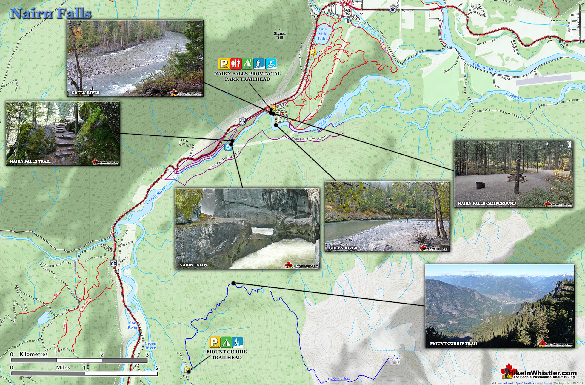
Though the BC Parks website describes Nairn Falls as 60 metres high, the description is a bit misleading. You won't find a marvellously abrupt drop into a deep chasm like to see with Brandywine Falls. Nairn Falls has a very different shape to it, but is every bit as interesting and scenic. More so, in fact, due to the interesting geological information you find at the main viewpoint over the falls.  Nairn Falls crash through various narrow and wide areas, and though the cumulative drop is 60 metres, what you see is a series of 10 to 20 metre falls through a deep, zig-zagging canyon. There are very nicely constructed railings, fences and viewing areas as well as a walkway that guides you to the best views. With such abruptly steep rock all around, the area would be potentially dangerous. Evidently there have been deaths here before. A cross, reverently placed across the chasm from the viewing platform, indicates of some tragic event. Nairn Falls Provincial Park is located just a short 20 to 30 minute drive north of Whistler.  From the large parking lot the well marked trail runs along the Green River for 1.2 kilometres to Nairn Falls. The trail is very easy and is hike-able year-round. Though considerable snow falls in the winter months here, the popular trail remains easy to follow, and snowshoes are usually not needed. You will find the parking lot gate locked in the winter, so you can park outside the gate and walk in. In cold winter weather you may find some treacherous sections of trail. The trail is quite narrow and follows a course next to a very steep slope down to the rushing river. On many winter days you will find the trail icy and extremely slippery.

Though the main trail to Nairn Falls is the main focus of visitors to Nairn Falls Provincial Park, there are more trails to more sights. The Sea to Sky Trail and various other trails zig-zag to the south. A cute trail off the campground brings you down to the river and quite a scenic area at a large bend in the river. This is the place you can jump in the water on a hot day.

Nairn Falls Provincial Park - Hike in Whistler

Nairn Falls Potholes

Nairn Falls Hike in Whistler 15

Nairn Falls Aerial View

The Story of Nairn Falls

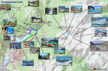
Nairn Falls Provincial Park Map

Nairn Falls Provincial ParkMost visitors to Nairn Falls Provincial Park just see the falls, however, to the left, beyond the campsites the Green River is beautiful.  A short trail takes you down to a wide bend in the river and you find yourself in what looks like a large beach. It is a hidden bit of paradise with the crystal clear, green water flowing over polished rocks. The whole are is in almost constant sunlight despite being in the middle of the forest. On warm, summer days you will find people swimming, sipping beers on the rock cliffs across the river and generally having an amazing time in this usually forgotten corner of the park.

Nairn Falls Large Map v7

Getting to Nairn Falls

Driving to the TrailheadNairn Falls is very easy to find, just a 20-30 minute drive north of Whistler. From Whistler Village, zero your odometer at Village Gate Boulevard and head north on Highway 99(towards Pemberton), 29.1 kilometres from Whistler Village you will see the parking lot on your right and a huge Nairn Falls Provincial Park highway sign. There is a large, free parking area as you enter the park. If you drive further into the park you will find all the drive-to camping areas as well as the park warden's cabin. If you are just visiting the falls, parking at the main area just off the highway is best.  If you find the gate locked(after hours and in the winter), you can park along the edge of the highway.

Nairn Falls Driving Directions Map

More Nairn Falls Information

More Whistler & Garibaldi Park Hiking Maps!

Callaghan Lake Maps

Callaghan Lake Park is a relatively untouched wilderness of rugged mountainous terrain. The valley walls were formed by relatively recent glaciation. Evidence of this can be ...
Read more

Garibaldi Lake Maps

Garibaldi Lake is the centre and base for much of the hiking in Garibaldi Provincial Park. The Garibaldi Lake campsite is located on the amazing, turquoise shores of this massive ...
Read more

Cheakamus Lake Maps

Cheakamus Lake is a wonderfully relaxing way to get in the wilderness easily and quickly from Whistler Village.  The trail begins on the far side of Whistler Mountain, 8 ...
Read more

Parkhurst Ghost Town Maps

Whistler has an absurd number of wonderful and free hiking trails and Parkhurst Ghost Town certainly ranks as one of the most unusual, exotic and interesting. Parkhurst was a little ...
Read more
More Whistler Hiking Trail Maps
 

Amazing West Coast Trail Highlights

Whistler & Garibaldi Park Glossary A to Z

Waterbar and Cross-Ditch: the purpose of a waterbar or cross-ditch is to capture and redirect surface water from the road and channel it across the road ...
Read more
The Coast Mountains run from the Yukon down to Vancouver along the west coast of British Columbia in a band that averages 300 kilometres wide(190 miles).  ...
Read more
The Garibaldi Ranges are a subdivision of the Pacific Ranges of the Coast Mountains.  Deriving its name from Mount Garibaldi, the Garibaldi Ranges cover the huge ...
Read more
The Garibaldi Volcanic Belt is a line of mostly dormant stratovolcanoes and subglacial volcanoes largely centred around Whistler and extending through much ...
Read more
Paper birch, also known as white birch is a type of birch tree that grows in northern North America. Named for its paper-like, white or cream coloured ...
Read more
Mount Garibaldi is the huge, potentially active volcano that Garibaldi Provincial Park is named after.  Mount Garibaldi also lends its name to the Garibaldi ...
Read more
Bergschrund or abbreviated schrund: a crevasse that forms from the separation of moving glacier ice from the stagnant ice above. Characterized by a deep ...
Read more
Along the shore of Green Lake, you will find a monstrous old Caterpillar tractor that dates from the 1930’s.  Abandoned here in the 1950’s, it looks as if the ...
Read more
More Hike in Whistler Glossary

Free Camping Gear Delivery to Garibaldi Park

The Best Whistler & Garibaldi Park Hiking Trails!

Blackcomb Mountain holds an impressive and ever growing array of hiking trails. From the moment you arrive at the Rendezvous Lodge, you see hiking trails ascend into the distance. The Rendezvous Lodge is ...
Read more
Whistler has an absurd number of wonderful and free hiking trails and Parkhurst Ghost Town certainly ranks as the most unusual and interesting. Parkhurst was a little logging town perched on the edge of Green ...
Read more
The short, winding, and ever-changing hiking trail to Rainbow Falls is the same as the much more popular trailhead for Rainbow Lake.  The trailhead is marked as the Rainbow Trail, and the trail quickly ...
Read more
Taylor Meadows is a very scenic campsite and great alternative to the much busier and more well known, Garibaldi Lake campsite. Located in Garibaldi Provincial Park between Garibaldi Lake and Black Tusk, ...
Read more
More Whistler Hiking Trails & Maps

HikeInWhistler.com HikeInWhistler.com © 2025
  • Contact Us: [email protected]