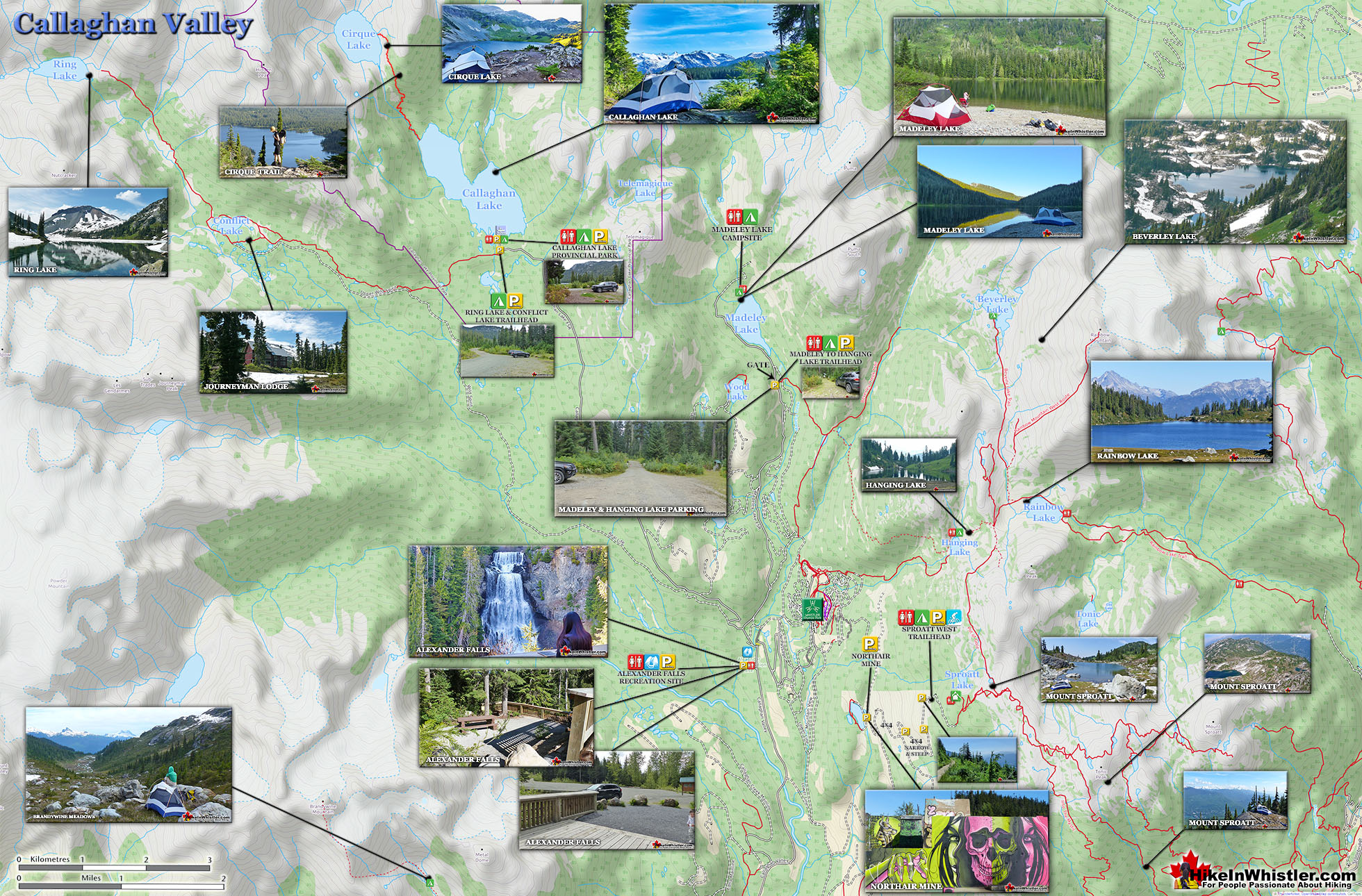
![]() Cirque Lake is a wild and beautiful lake that hides high above and beyond Callaghan Lake in Callaghan Lake Provincial Park. What makes Cirque Lake special among the other sensationally beautiful lakes in the Whistler area is both its location and geologically formed shape. It sits high above Callaghan Lake, which itself is a gorgeous, mountain lake. The remoteness of Callaghan Lake is a bit of a mirage due to the fact that you can drive right to it!
Cirque Lake is a wild and beautiful lake that hides high above and beyond Callaghan Lake in Callaghan Lake Provincial Park. What makes Cirque Lake special among the other sensationally beautiful lakes in the Whistler area is both its location and geologically formed shape. It sits high above Callaghan Lake, which itself is a gorgeous, mountain lake. The remoteness of Callaghan Lake is a bit of a mirage due to the fact that you can drive right to it!
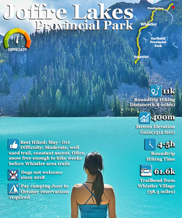
 Seldom hiked & relatively untouched
- Stunning lake created by glaciation
- Alpine terrain to explore beyond the lake
- Shielded against the cold mountain winds
- Brilliantly bright on a sunny day
- Sits in a hidden world in the mountains
- Starting your hike from a canoe is fun
- Callaghan Lake is a destination on its own
- The drive to Callaghan is beautifully scenic
 Brutally cold swimming!
Callaghan Lake is accessible via an 8 kilometre weather battered and very potholed forest service road. The entire road is cratered with deep potholes, cut by frequent cross-ditches, and more recently a small section collapsing into the valley below. This logging road begins high up in the Callaghan Valley, which itself is largely overlooked by travellers to Whistler. The Callaghan Valley is home to quite a few natural and man-made attractions. Brandywine Meadows, Alexander Falls, Northair Mine and Mount Sproatt are all found in the valley. Recently, the 2010 Olympic Games produced the largest man-made attraction in Callaghan Valley, Whistler Olympic Park. Though Cirque Lake is tremendously far into the wilderness, the amount of hiking required to reach it is effectively less than two kilometres. Another two kilometres of canoeing is required to reach the trailhead at the far end of Callaghan Lake. But for such an enchantingly beautiful, mountain lake, the exertion to reach it is remarkably little. The other attribute of Cirque Lake that makes it special, is its cirque structure. From the moment you catch sight of Cirque Lake, the abruptly steep sides all around give you the humbling feeling that you are inside a volcano. A volcano filled with emerald water and ringed by grassy meadows and crumbling, near vertical cliffs. Where you stand, at the entrance to the cirque, is not far from the only water channel out of the cirque. An ever narrowing gap in the cliffs spills water down one cliff after another until reaching Callaghan Lake just 1.4 kilometres away.
Cirque Lake Hiking Trail Map

Owing to the fact that you have to reach the trailhead to Cirque Lake by boat ensures that it almost always remains deserted. Even in the middle of summer, your tent will almost certainly be the only one that resides in this magical cirque. You sometimes get hikers venturing up from their campsites at Callaghan Lake for a couple hours, otherwise nobody. One feature of the Cirque Lake trail that no doubt scares hikers away is its steepness and ruggedness. It is mostly very steep, and due to the obliterating effects of winter snow, the trail markers are sporadic at best. One consolation is of course the length of the trail. Under two kilometres, makes the steepness much easier to tackle. With a heavy pack you can easily hike the trail in a little over an hour. Or an hour and a half or two if you linger at the frequent viewpoints looking back on Callaghan Lake. The eruption of blueberry bushes in August is cause for some delays as well as it is surprisingly hard to pass up feasting on every bush you see.. and you will see a lot. The trail, for the most part is quite scenic and enjoyable. The first 15 minutes of the trail winds through a cute forest along and over some small streams. The next 15 minutes takes you up some steeper and more challenging terrain that require pulling yourself up with tree roots and at one section a knotted rope.

Thirty minutes into the trail brings you to a massive boulder field that you have to budget your attention between the treacherous boulders ahead and the incredible views of Callaghan Lake behind. The final 15 minutes of the trail is the most enjoyable of all. Summiting the ridge that takes you to the access point entrance to Cirque Lake. This ridge has a clearing with breathtaking views overlooking Callaghan Lake. So beautiful that you will be tempted to drop your pack and spend the night. The real marvel of course lays just 5 minutes ahead.
Callaghan Lake Parking and Boat Launch Map

Parking & Trailhead Directions to Cirque Lake
![]()
![]()
![]() The trailhead to Cirque Lake is found at the far end of Callaghan Lake. Callaghan Lake Provincial Park is less than an hours drive from Whistler Village and most of the drive is quite beautiful. From Whistler drive 13.8 kilometres towards Vancouver on the Sea to Sky Highway. Turn right onto Callaghan Valley Road at the sign for Whistler Olympic Park. Drive up the beautiful, winding road for 9.6 kilometres. The sign for Callaghan Lake Provincial Park will be just after Alexander Falls Provincial Park and just before Whistler Olympic Park. You will turn left, cross a bridge and drive up the horrendously potholed Callaghan Lake FSR for 8.5 kilometres. Most vehicles can make it to the lake but with extreme caution and care at several waterbars and the frequent and very deep potholes. You often see full size motorhomes at the campsite so as long as you drive slow, most vehicles should make it slowly but surely. This logging road is usually deep with snow until June(June 4th in 2019). If you attempt to drive this road in early summer, be sure to bring a shovel and rope in case you find yourself stuck in the snow. You will have spotty cell reception all the way to the Callaghan campsite, however you may have to walk along the road until you catch a usable signal. Access to Callaghan Lake FSR is blocked by a chain at the bridge until May 15th every year. A huge pile of snow is plowed to block Callaghan Lake FSR just past the bridge. It keeps people from driving up and getting stuck in the snow on the higher elevations. When this snow pile melts, it is a good indication that the road to Callaghan Lake may be clear as well.
The trailhead to Cirque Lake is found at the far end of Callaghan Lake. Callaghan Lake Provincial Park is less than an hours drive from Whistler Village and most of the drive is quite beautiful. From Whistler drive 13.8 kilometres towards Vancouver on the Sea to Sky Highway. Turn right onto Callaghan Valley Road at the sign for Whistler Olympic Park. Drive up the beautiful, winding road for 9.6 kilometres. The sign for Callaghan Lake Provincial Park will be just after Alexander Falls Provincial Park and just before Whistler Olympic Park. You will turn left, cross a bridge and drive up the horrendously potholed Callaghan Lake FSR for 8.5 kilometres. Most vehicles can make it to the lake but with extreme caution and care at several waterbars and the frequent and very deep potholes. You often see full size motorhomes at the campsite so as long as you drive slow, most vehicles should make it slowly but surely. This logging road is usually deep with snow until June(June 4th in 2019). If you attempt to drive this road in early summer, be sure to bring a shovel and rope in case you find yourself stuck in the snow. You will have spotty cell reception all the way to the Callaghan campsite, however you may have to walk along the road until you catch a usable signal. Access to Callaghan Lake FSR is blocked by a chain at the bridge until May 15th every year. A huge pile of snow is plowed to block Callaghan Lake FSR just past the bridge. It keeps people from driving up and getting stuck in the snow on the higher elevations. When this snow pile melts, it is a good indication that the road to Callaghan Lake may be clear as well.


Finding the Hidden Cirque Lake Trailhead
![]() To reach the very hidden trailhead to Cirque Lake, paddle your canoe towards the waterfall far off in the distance. Not until you are only 50 metres from the shore, nearest the sound of the now hidden waterfall, you will see a small clearing jutting out from the shore, this is the trailhead, despite it not looking like one. Pull your canoe up here and drag into the bushes. Only a few metres into shore you will notice an obvious trail. There are even plenty of tree markers on the way. From here it is only an hour hike to the lake, though even steeper than the Wedgemount Lake trail. About two thirds of the way up the trail you will come to a massive boulder field. The trail emerges from the forest into this field and cuts across it. You then hike the precarious boulder field along the right side. The route zig-zags all the while following several not so obviously placed cairns and orange trail marker ribbons. At the top of the boulder field you will have to climb up a narrow cliff gap with an impressive array of brutalized krummholz trees. These boulder mangled trees, bent and twisted by the crushing weight of snow and rockfalls. From this gap to Cirque Lake is only another 15 minutes of ever more beautiful views.
To reach the very hidden trailhead to Cirque Lake, paddle your canoe towards the waterfall far off in the distance. Not until you are only 50 metres from the shore, nearest the sound of the now hidden waterfall, you will see a small clearing jutting out from the shore, this is the trailhead, despite it not looking like one. Pull your canoe up here and drag into the bushes. Only a few metres into shore you will notice an obvious trail. There are even plenty of tree markers on the way. From here it is only an hour hike to the lake, though even steeper than the Wedgemount Lake trail. About two thirds of the way up the trail you will come to a massive boulder field. The trail emerges from the forest into this field and cuts across it. You then hike the precarious boulder field along the right side. The route zig-zags all the while following several not so obviously placed cairns and orange trail marker ribbons. At the top of the boulder field you will have to climb up a narrow cliff gap with an impressive array of brutalized krummholz trees. These boulder mangled trees, bent and twisted by the crushing weight of snow and rockfalls. From this gap to Cirque Lake is only another 15 minutes of ever more beautiful views.

More Great Hiking in the Callaghan Valley
![]() The Callaghan Valley lays quietly across from Whistler despite being home to some incredible hikes. Ring & Conflict Lake and Cirque Lake are two phenomenal hiking destinations in the valley that few people have even heard of. Cirque Lake resides high above Callaghan Lake at the end of a very steep, though very short hike that runs startlingly close to the almost vertical falls that empty Cirque Lake. Ring & Conflict Lake sit high up in the mountains 10 kilometres west of Callaghan Lake. You will never, or at least comparatively rarely see anyone on the trails to Cirque Lake, Ring & Conflict Lake for several reasons. First is location. Despite the Callaghan Valley being tremendously beautiful geographically. The distant mountains are snow covered, even in September. The lakes are emerald coloured and crystal clear. The forests are an untouched blanket of beautiful green. The creeks, rivers and waterfalls are everywhere in your view or if not in view, heard as distant sounds of running water. Despite this beauty, it seems that the biggest reason for the Callaghan Valley's lack of use as a hiking destination is its location next to Garibaldi Park. The beautiful and well known park focuses all the throngs of hikers in the justifiably popular areas of Garibaldi Lake, Black Tusk, Taylor Meadows, Wedgemount Lake and Elfin Lakes. Laying outside this monstrously famous Provincial Park exists the relatively untouched and unknown Callaghan Valley. The second big reason of course is that the hikes in the Callaghan Valley are unmaintained or at least rarely maintained. The campsite at Callaghan Lake is maintained to a very high standard, however the trail to Cirque Lake evidently doesn't fall into any park jurisdiction and finding the unmarked trailhead is a challenge. There are flagging tapes along the trail after the trailhead. The third reason, at least for Cirque Lake, for being hardly hiked is the fact that the unmarked trailhead starts at the far end of Callaghan Lake. So you need to canoe or otherwise, boat there. This added impediment surely contributes to this wonderful trail, continuing to be infrequently hiked. The fourth, more practical, yet inexplicable reason is that the road to Callaghan Lake Provincial Park is horribly unmaintained. Obviously grading this poor logging road is expensive, however it is beyond neglected. Boulders, waterbars and potholes exist on this road to such a high degree that the neglect seems malicious. In fact, the moment you leave the deluxe road to the Olympic Nordic Centre the monstrous potholes begin, presumably scaring away any 4x4 lacking tourists Callaghan Lake Provincial Park bound. The Callaghan Valley gets a lot of drive in traffic since the recent paving of the road and installation of Whistler Olympic Park for the 2010 Olympics. This road is open year-round and in the summer is frequented by bear watchers. The grass along the road is a favourite for bears and in the summer months consistently ensures at least a couple bears along the route to the Callaghan Valley. Whistler has quite a few beautiful waterfalls to see. From Squamish there is Shannon Falls, then Brandywine Falls closer to Whistler. Rainbow Falls in Whistler and Nairn Falls twenty minutes north. Out of these, Alexander Falls in the Callaghan Valley is both impressively huge and convenient to see. It is located just before the turnoff to Callaghan Lake. You can drive to the viewing platform and actually see the falls without leaving your car.
The Callaghan Valley lays quietly across from Whistler despite being home to some incredible hikes. Ring & Conflict Lake and Cirque Lake are two phenomenal hiking destinations in the valley that few people have even heard of. Cirque Lake resides high above Callaghan Lake at the end of a very steep, though very short hike that runs startlingly close to the almost vertical falls that empty Cirque Lake. Ring & Conflict Lake sit high up in the mountains 10 kilometres west of Callaghan Lake. You will never, or at least comparatively rarely see anyone on the trails to Cirque Lake, Ring & Conflict Lake for several reasons. First is location. Despite the Callaghan Valley being tremendously beautiful geographically. The distant mountains are snow covered, even in September. The lakes are emerald coloured and crystal clear. The forests are an untouched blanket of beautiful green. The creeks, rivers and waterfalls are everywhere in your view or if not in view, heard as distant sounds of running water. Despite this beauty, it seems that the biggest reason for the Callaghan Valley's lack of use as a hiking destination is its location next to Garibaldi Park. The beautiful and well known park focuses all the throngs of hikers in the justifiably popular areas of Garibaldi Lake, Black Tusk, Taylor Meadows, Wedgemount Lake and Elfin Lakes. Laying outside this monstrously famous Provincial Park exists the relatively untouched and unknown Callaghan Valley. The second big reason of course is that the hikes in the Callaghan Valley are unmaintained or at least rarely maintained. The campsite at Callaghan Lake is maintained to a very high standard, however the trail to Cirque Lake evidently doesn't fall into any park jurisdiction and finding the unmarked trailhead is a challenge. There are flagging tapes along the trail after the trailhead. The third reason, at least for Cirque Lake, for being hardly hiked is the fact that the unmarked trailhead starts at the far end of Callaghan Lake. So you need to canoe or otherwise, boat there. This added impediment surely contributes to this wonderful trail, continuing to be infrequently hiked. The fourth, more practical, yet inexplicable reason is that the road to Callaghan Lake Provincial Park is horribly unmaintained. Obviously grading this poor logging road is expensive, however it is beyond neglected. Boulders, waterbars and potholes exist on this road to such a high degree that the neglect seems malicious. In fact, the moment you leave the deluxe road to the Olympic Nordic Centre the monstrous potholes begin, presumably scaring away any 4x4 lacking tourists Callaghan Lake Provincial Park bound. The Callaghan Valley gets a lot of drive in traffic since the recent paving of the road and installation of Whistler Olympic Park for the 2010 Olympics. This road is open year-round and in the summer is frequented by bear watchers. The grass along the road is a favourite for bears and in the summer months consistently ensures at least a couple bears along the route to the Callaghan Valley. Whistler has quite a few beautiful waterfalls to see. From Squamish there is Shannon Falls, then Brandywine Falls closer to Whistler. Rainbow Falls in Whistler and Nairn Falls twenty minutes north. Out of these, Alexander Falls in the Callaghan Valley is both impressively huge and convenient to see. It is located just before the turnoff to Callaghan Lake. You can drive to the viewing platform and actually see the falls without leaving your car.

More details, directions and maps for Cirque Lake.
More Whistler & Garibaldi Park Hiking Maps!

Ancient Cedars Maps
Brew Lake Maps
Rainbow Falls Maps
Skookumchuck Hot Springs Maps

Whistler & Garibaldi Park Glossary A to Z


The Best Whistler & Garibaldi Park Hiking Trails!