HikeInWhistler.com

HikeInWhistler.com

Menu
  • Hike
      • Alexander Falls Provincial Park
      • Ancient Cedars & Showh Lakes
      • Black Tusk in Garibaldi Park
      • Blackcomb Mountain Hiking Trails
      • Brandywine Falls Provincial Park
      • Brandywine Meadows
      • Brew Lake & Mount Brew
      • Callaghan Lake Park
      • Cheakamus Lake in Garibaldi Park
      • Cheakamus River & Interpretive Forest
      • Cirque Lake in Callaghan Valley
      • Flank Trail (Rainbow-Sproatt)
      • Garibaldi Lake in Garibaldi Park
      • Helm Creek in Garibaldi Park
      • Jane Lakes West
      • Joffre Lakes Provincial Park
      • Keyhole Hot Springs
      • Logger's Lake
      • Madeley Lake & Hanging Lake
      • Meager Hot Springs
      • Nairn Falls Provincial Park
      • Newt Lake & Ancient Cedars
      • Panorama Ridge in Garibaldi Park
      • Parkhurst Ghost Town
      • Rainbow Falls
      • Rainbow Lake
      • Ring Lake & Conflict Lake
      • Russet Lake in Garibaldi Park
      • Sea to Sky Trail
      • Skookumchuck Hot Springs
      • Sloquet Hot Springs
      • Sproatt West(Northair) Trail
      • Sproatt East(Stonebridge) Trail
      • Train Wreck & Trash Trail
      • Taylor Meadows in Garibaldi Park
      • Wedgemount Lake in Garibaldi Park
      • Whistler Mountain Hiking Trails
  • Snow
      • Blueberry Trail Snowshoeing
      • Brandywine Falls Snowshoeing
      • Cheakamus River Snowshoeing
      • Elfin Lakes Snowshoeing
      • Flank Trail Snowshoeing
      • Joffre Lakes Snowshoeing
      • Nairn Falls Snowshoeing
      • Parkhurst Ghost Town Snowshoeing
      • Rainbow Falls Snowshoeing
      • Rainbow Lake Snowshoeing
      • Rainbow Park Snowshoeing
      • Sproatt East Snowshoeing
      • Taylor Meadows Snowshoeing
      • Train Wreck Snowshoeing
      • Wedgemount Lake Snowshoeing
  • Run
      • Whistler Golf Course 5k(3.1 Mile)
      • Blueberry Hill 6k(3.7 Mile)
      • Lost Lake 6k(3.7 Mile)
      • Alta Lake 8k(5 Mile)
      • Fitzsimmons Creek 9k(5.6 Mile)
      • Alta Green Lost 15k(9.3 Mile)
  • Best
      • Best Whistler Hiking by Month
          • Best by Month
      • Best Walk, Bike or Bus To Trails
      • Best Whistler Kid Friendly Trails
      • Best Whistler Dog Friendly Trails
      • Best Free Camping in Whistler
      • Best Sights Sea to Sky
      • Best Whistler Waterfalls
      • Best Whistler Aerial Views
      • Best Squamish Hiking Trails
      • Best Whistler Hiking Trails
      • Best Vancouver Hiking Trails
      • Best Whistler Snowshoeing
          • Best Whistler Snowshoe Trails
      • Best Whistler Running Trails
      • Best Whistler Hiking Gear Rentals
      • Best Whistler Parks & Beaches
  • AtoZ
      • Ablation Zone
      • Accumulation Zone
      • Adit Lakes
      • Aiguille
      • Alpine Zone
      • Arborlith or Lithophyte
      • Arête
      • A River Runs Through It
      • Armchair Glacier
      • The Barrier
      • Battleship Islands
      • Bears
      • Bench
      • Bergschrund or Schrund
      • Bivouac or Bivy
      • Blue Face House in Parkhurst
      • Bungee Bridge
      • Cairns & Inukshuks
      • Carter, Neal
      • Caterpillar D8
      • Caterpillar RD8
      • Chimney
      • Cirque or Cirque Lake
      • Cloudraker Skybridge
      • Coast Mountains
      • Col
      • Crevasse
      • Deadfall
      • Emerald Forest
      • Erratic or Glacier Erratic
      • The Fissile
      • Fitzsimmons Creek
      • Fitzsimmons Range
      • Fyles, Tom
      • Garibaldi Ranges
      • Garibaldi Volcanic Belt
      • Gemel or Inosculation
      • Glacier Window
      • Green Lake
      • Hoary Marmot
      • Krummholz
      • Moraine
      • Mount Garibaldi
      • Mount James Turner
      • Northair Mine
      • Nunatuk
      • Overlord Mountain & Glacier
      • Peak2Peak Gondola
      • Roundhouse Lodge
      • Rubble Creek
      • Spearhead Range
      • Tarn
      • The Table
      • Usnea or Old Man's Beard
      • Western Redcedar
  • Maps
      • Alexander Falls Maps
      • Ancient Cedars Maps
      • Black Tusk Maps
      • Blackcomb Mountain Maps
      • Brandywine Falls Maps
      • Brandywine Meadows Maps
      • Brew Lake Maps
      • Callaghan Lake Maps
      • Cheakamus Lake Maps
      • Cheakamus River Maps
      • Cirque Lake Maps
      • Garibaldi Lake Maps
      • Helm Creek Maps
      • Joffre Lakes Maps
      • Keyhole Hot Springs Maps
      • Logger's Lake Maps
      • Madeley Lake Maps
      • Meager Hot Springs Maps
      • Nairn Falls Maps
      • Panorama Ridge Maps
      • Parkhurst Ghost Town Maps
      • Rainbow Falls Maps
      • Rainbow Lake Maps
      • Ring Lake Maps
      • Russet Lake Maps
      • Skookumchuck Maps
      • Sloquet Hot Springs Maps
      • Sproatt Maps
      • Taylor Meadows Maps
      • Train Wreck Maps
      • Wedgemount Lake Maps
      • Whistler Mountain Maps
  • More
      • Whistler Hiking News & Blog
      • Live Whistler Webcams
      • Live Tofino Webcams
      • Live Vancouver Webcams
      • Garibaldi Provincial Park
      • Hike in Whistler Glossary

Wedgemount Lake

Joffre Lakes

Black Tusk

Wedgemount Lake

Whistler Train Wreck

Black Tusk

Cirque Lake

Brandywine Meadows

Callaghan Lake

Adit Lakes

Newt Lake

Logger's Lake

Northair Mine

Spectacular Whistler!

Whistler hiking is wonderful! Check out our Best Whistler Hiking by Month guides! WeRentGear.com rents tents, sleeping bags, sleeping pads, camp stoves, packs, complete kits and more!

Best Trails This Week!

Best This Week: Whistler Train Wreck and Parkhurst Ghost Town are easy, fun and dog friendly. Check out our May and June Whistler and Garibaldi Park guides here!

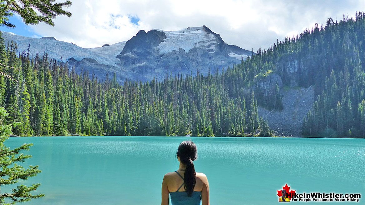
Joffre Lakes Hike RatingThe three Joffre Lakes are some of the most stunning lakes you are likely to ever see. Each lake gets progressively more beautiful and impossibly turquoise from one to the next.  By the third lake the intense colour is breathtaking. The mighty Matier Glacier rises above and beyond the third lake, making the experience even more spectacular with such a looming presence.  

  • Very scenic drive to get there
  • Less challenging than most other trails
  • Amazing lakes to marvel at their colour
  • The campsite is in a very natural setting
  • Free of snow & hikeable as early as April
  • Alpine terrain extends in many directions
  • One tent site is on an island!
  • Stunning glacier looms above the campsite
  • No longer dog friendly as of summer 2018
  • Overcrowded much of the summer

The Joffre Lakes trail is rough and tricky in some parts, but not terribly difficult. It is also short compared to Whistler area trails at just 5.5 kilometres(one way).  Hiking at a moderate pace, give yourself 1.5 - 2 hours to get to the third lake and campsites. Lots of trail construction work has been done in the past few years as a new trail has replaced much of the old trail. The old boulder section between the lower and middle lakes has now been covered with a new dirt trail.  Joffre Lakes Provincial Park is centred around the three Joffre Lakes. All of them are beautiful on their own and each more beautiful than the last. The amazing turquoise colours of the lakes are caused by light reflecting off of the particles of glacial silt suspended in the water. On the trail you will immediately catch glimpses of the massive glaciers that feed these gorgeous lakes.  In the winter, with the lakes frozen and the trees weighed down with snow, Joffre Lakes takes on a serene beauty, with the low sun cutting through the trees and the forest brightly reflecting.  Upper Joffre Lake ends in a U-shaped valley where you will find the far side of the lake towering with glaciers relentlessly crushing down on the lake.  The sun fills the valley and the silence is wonderful.  At Upper Joffre Lake there are several nice, though rugged places to camp. In a hilly, lightly forested section of paradise in between the impossibly turquoise Upper Joffre Lake and the abruptly monstrous Matier Glacier descending from Mount Matier beyond. A waterfall cascades near the camping area. The campsite has one nice and well maintained outhouse.

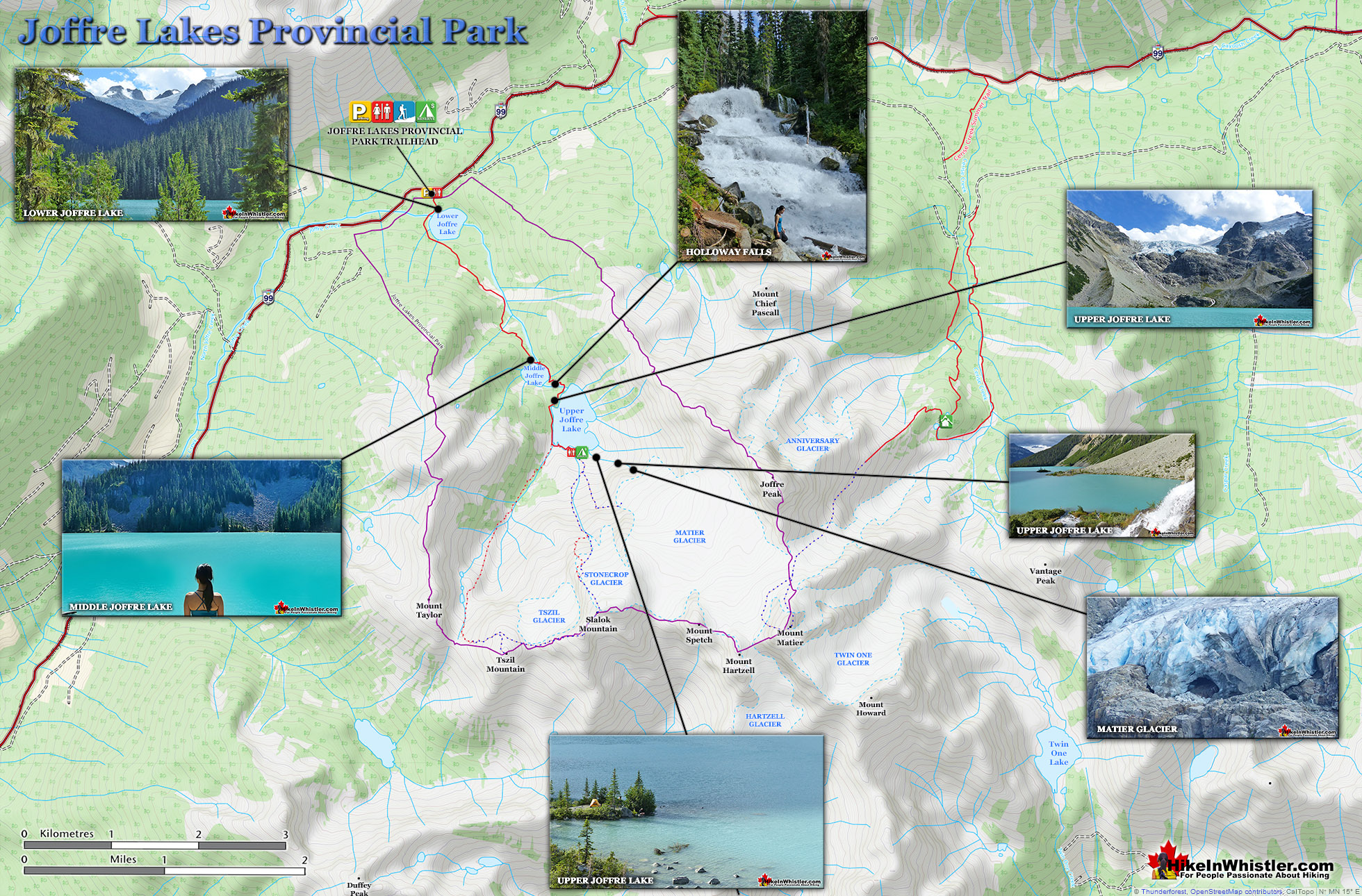
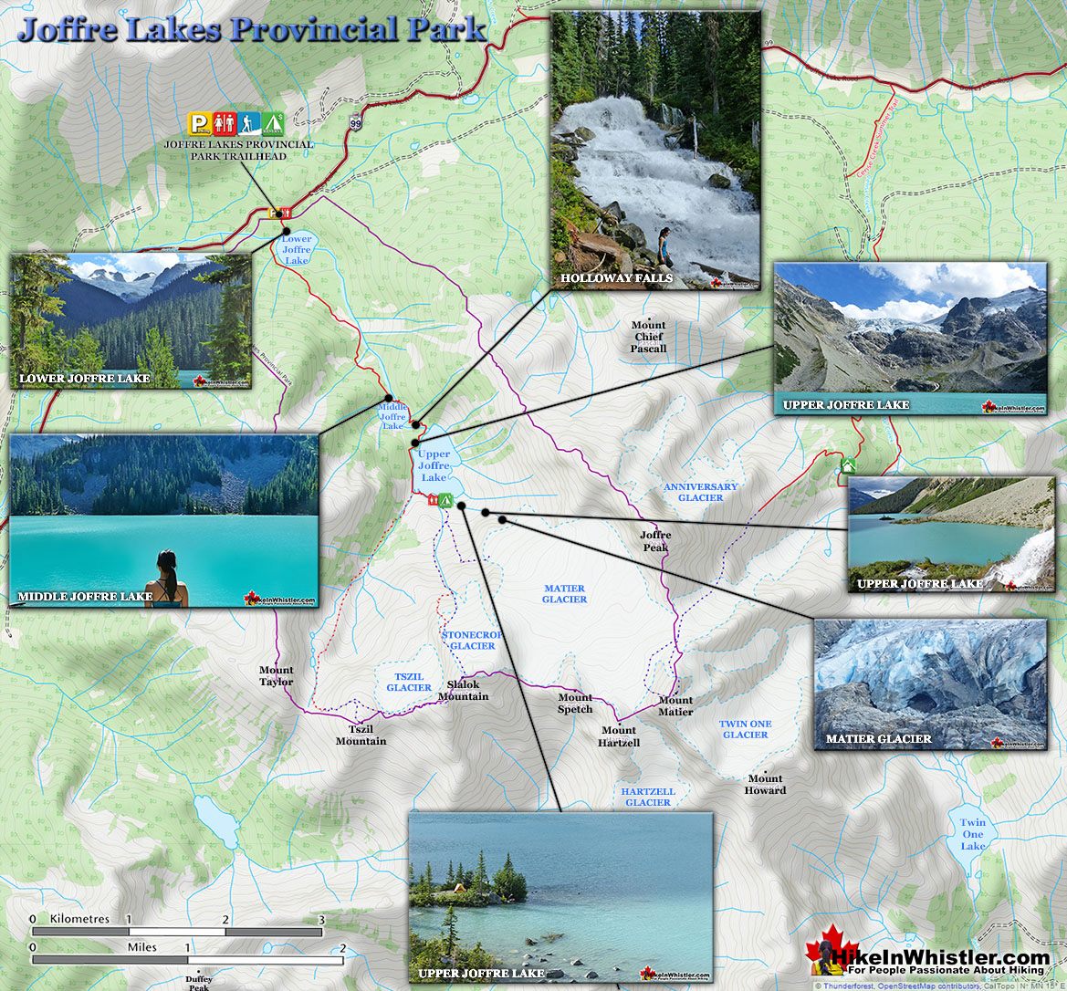
Joffre Lakes Map v14a

You will notice several clearings for tents in the gravel and boulder strewn landscape. Each one barely enough room for a tent, but the ruggedness adds to the beauty of Joffre Lakes. The park is wonderfully untouched by people. With the exception of the trail, some signs, outhouse and bridges, Joffre Lakes Provincial Park is beautifully wild and picturesque. There is also a prominent helicopter pad close by as a reminder of how many injuries occur on the trail and the accessible mountains and glaciers around. There are in fact four distinct glaciers close by, Matier, Anniversary, Stonecrop and Tszil. Beyond Mount Matier there are two more, Twin One and Hartzell.

The Joffre Lakes trail is surprisingly busy most of the summer, which is a testament to how extraordinarily beautiful the lakes are, and how relatively easy the hike is. Unlike Wedgemount Lake, Black Tusk or Cirque Lake, which are to difficult for many hikers, Joffre Lakes is comparatively easy and certainly relaxing. Many hikes in the nearby Garibaldi Park are not family friendly and easy, but Joffre Lakes is.  Certainly the scenic drive to the trailhead from Whistler is part of the fun.
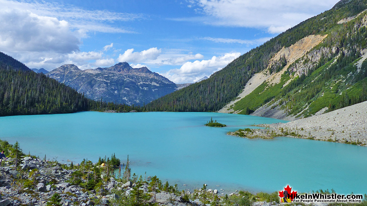
Joffre Lakes Provincial Park

Middle Joffre Lake

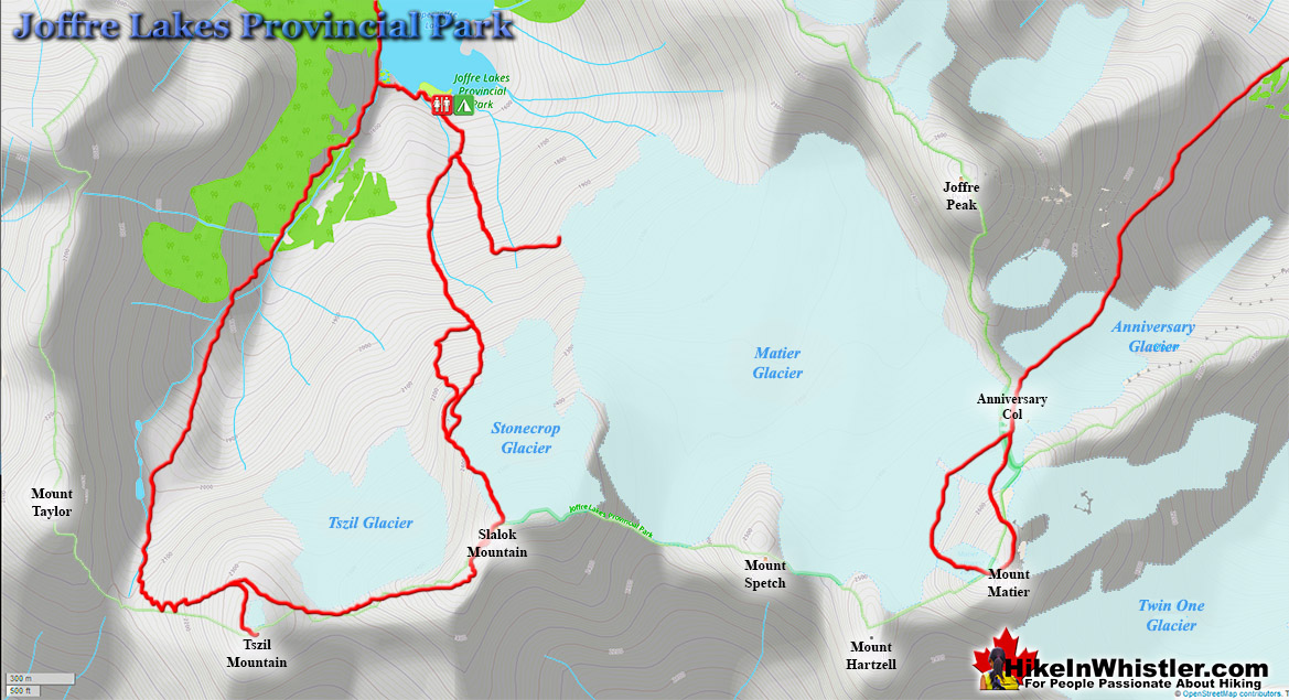
In terms of difficulty, Joffre Lakes is easier than most other Whistler and Garibaldi Park hiking trails.  Wedgemount Lake, Black Tusk, Panorama Ridge, Brew Lake and Brandywine Meadows are all considerably more strenuous, steeper and longer trails.  Like the trails in Garibaldi Park and Whistler, the Joffre Lakes trail is very well marked and easy to follow.  Expect to take two or three hours to hike up and one or two hours to hike back down.  The beautiful lake views and the foot of Matier Glacier will add an hour or two of exploring.  There are a couple very challenging hiking routes that veer off from Upper Joffre Lake that take you further up in the mountains.  There is a difficult route to Tszil Mountain and Tszil Glacier as well as a route to Stonecrop Glacier.  These two connect at Slalok Mountain via the Slalok Scramble Route.  These are tough and challenging places to hike with considerably more hazards to contend with than the relatively mild Joffre Lakes trail.  Because these two routes connect at the top, you can start and finish at Upper Joffre Lake and never have to retrace your route.  A beautiful option if you are experienced, well equipped and adventurous.

Joffre Lakes Provincial Park Glaciers Map

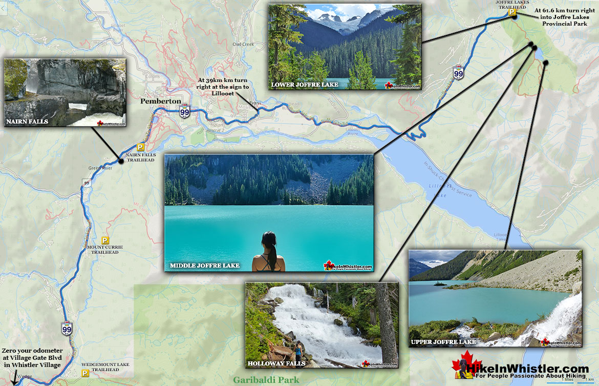
Joffre Lakes Directions Map v7

More hiking info for Joffre Lakes...

More Whistler & Garibaldi Park Hiking Maps!
Wedgemount Lake Maps

Wedgemount Lake itself is a magnificent destination for a day hike or spectacular overnight beneath the dazzling mountain peaks and stars. Many sleep under the stars on one of ...
Read more

Cheakamus River Maps

Cheakamus River is the beautiful, crashing and turquoise coloured river that flows from Cheakamus Lake, through the Cheakamus Valley to Daisy Lake.  Also a popular kayaking ...
Read more

Panorama Ridge Maps

Panorama Ridge is easily one of the most amazing hikes in Garibaldi Provincial Park.  The 15 kilometre hike from the trailhead at Rubble Creek to Panorama Ridge takes you ...
Read more

Parkhurst Ghost Town Maps

Whistler has an absurd number of wonderful and free hiking trails and Parkhurst Ghost Town certainly ranks as one of the most unusual, exotic and interesting. Parkhurst was a little ...
Read more
More Whistler Hiking Trail Maps

West Coast Trail Best Sights

Whistler & Garibaldi Park Glossary A to Z
Charles Townsend (1900-1997) moved from London, England to Vancouver in the early 1920's where he met Neal Carter while studying Agriculture at UBC. Townsend was ...
Read more
Parkhurst Ridge is an incredible place for a lot of reasons.  Of course, the view is spectacular with Green Lake's absurdly vivid green coloured water.  ...
Read more
Western redcedar is a very large tree commonly found in the Pacific Northwest. Frequently growing up to 70 metres and with a trunk diameter of 7 metres, ...
Read more
Deadfall means a tangled mass of fallen trees and branches.  There are several name variations for fallen trees that are commonly used in Whistler.  ...
Read more
Corrie Lake is the surreal looking lake that can be seen across the valley from Whistler Mountain.  While hiking the High Note trail along Whistler ...
Read more
The sawmill at Parkhurst operated on the triangle of land that juts out into Green Lake and also extended north between the train tracks and the lake.  The ...
Read more
Paper birch, also known as white birch is a type of birch tree that grows in northern North America. Named for its paper-like, white or cream coloured ...
Read more
Chimney: a gap between two vertical faces of rock or ice.  Often a chimney offers the only viable route to the summit of a mountain.  An example of this is Black ...
Read more
More Hike in Whistler Glossary

Free Camping Gear Delivery to Garibaldi Park

The Best Whistler & Garibaldi Park Hiking Trails!
The alpine hiking trails on Whistler Mountain are the ultimate in luxurious, quick-access alpine hiking. Little effort gets you amazing views of turquoise lakes, snowy mountains, valleys of flowers and ...
Read more
Skookumchuck Hot Springs(aka T'sek Hot Springs and St. Agnes Well), located two hours north of Whistler along the edge of the huge Lillooet River. The name Skookumchuck means "strong water" in the language ...
Read more
Meager Hot Springs(aka: Meager Creek Hot Springs) is located 93 kilometres northwest of Whistler, was beautifully developed into gorgeous pools, with a caretaker and usage charge.  At its height of ...
Read more
Ancient Cedars is a nice, easy/moderate 2.5 kilometre (1.6 mile) hiking trail on the far side of Cougar Mountain, just 13.1 kilometres north of Whistler Village. A small, untouched grove of huge western ...
Read more
More Whistler Hiking Trails & Maps

HikeInWhistler.com HikeInWhistler.com © 2025
  • Contact Us: [email protected]