![]() Wedge Creek cuts through the valley that separates Wedge Mountain and Blackcomb Mountain and empties into Green River near the north end of Green Lake. Wedge Creek is notable for the mountain pass between Wedge and Blackcomb that runs between it and Billygoat Creek. The original name for the pass, officially adopted in 1930 was Wedgemount Pass, however it was changed in 1957 to Wedge Pass to avoid confusion with nearby Wedgemount Creek which flows from Wedgemount Lake.
Wedge Creek cuts through the valley that separates Wedge Mountain and Blackcomb Mountain and empties into Green River near the north end of Green Lake. Wedge Creek is notable for the mountain pass between Wedge and Blackcomb that runs between it and Billygoat Creek. The original name for the pass, officially adopted in 1930 was Wedgemount Pass, however it was changed in 1957 to Wedge Pass to avoid confusion with nearby Wedgemount Creek which flows from Wedgemount Lake.
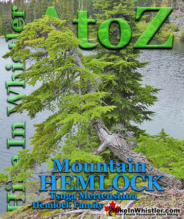
Whistler & Garibaldi Hiking
![]() Alexander Falls
Alexander Falls ![]() Ancient Cedars
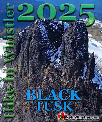
Ancient Cedars ![]() Black Tusk
Black Tusk ![]() Blackcomb Mountain
Blackcomb Mountain ![]() Brandywine Falls
Brandywine Falls ![]() Brandywine Meadows
Brandywine Meadows ![]() Brew Lake
Brew Lake ![]() Callaghan Lake
Callaghan Lake ![]() Cheakamus Lake
Cheakamus Lake ![]() Cheakamus River
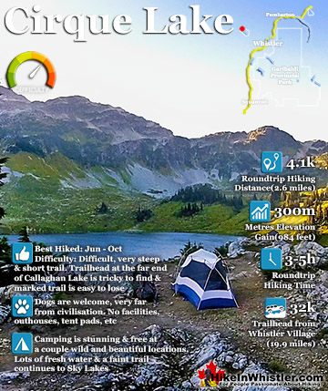
Cheakamus River ![]() Cirque Lake
Cirque Lake ![]() Flank Trail
Flank Trail ![]() Garibaldi Lake
Garibaldi Lake ![]() Garibaldi Park
Garibaldi Park ![]() Helm Creek
Helm Creek ![]() Jane Lakes
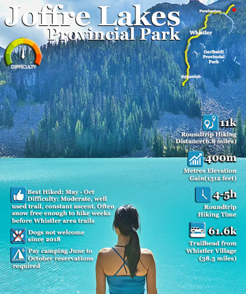
Jane Lakes ![]() Joffre Lakes
Joffre Lakes ![]() Keyhole Hot Springs
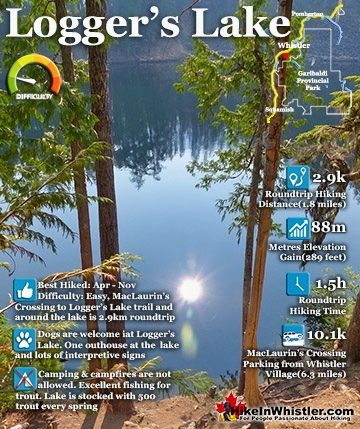
Keyhole Hot Springs ![]() Logger’s Lake
Logger’s Lake ![]() Madeley Lake
Madeley Lake ![]() Meager Hot Springs
Meager Hot Springs ![]() Nairn Falls
Nairn Falls ![]() Newt Lake
Newt Lake ![]() Panorama Ridge
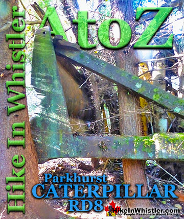
Panorama Ridge ![]() Parkhurst Ghost Town
Parkhurst Ghost Town ![]() Rainbow Falls
Rainbow Falls ![]() Rainbow Lake
Rainbow Lake ![]() Ring Lake
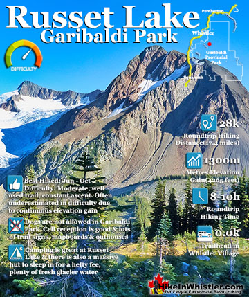
Ring Lake ![]() Russet Lake
Russet Lake ![]() Sea to Sky Trail
Sea to Sky Trail ![]() Skookumchuck Hot Springs
Skookumchuck Hot Springs ![]() Sloquet Hot Springs
Sloquet Hot Springs ![]() Sproatt East
Sproatt East ![]() Sproatt West
Sproatt West ![]() Taylor Meadows
Taylor Meadows ![]() Train Wreck
Train Wreck ![]() Wedgemount Lake
Wedgemount Lake ![]() Whistler Mountain
Whistler Mountain
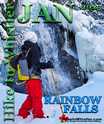
![]() January
January ![]() February
February ![]() March
March ![]() April
April ![]() May
May ![]() June
June ![]() July
July ![]() August
August ![]() September
September ![]() October
October ![]() November
November ![]() December
December
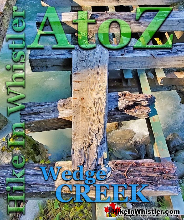
Wedge Creek is also known by its crumbling, skeleton-like and strangely beautiful Wedge Creek bridge that is located near the unmarked trailhead to Parkhurst Ghost Town in Whistler. It is fitting that a ghost town would have such a sturdy, yet old and abandoned bridge at its beginning. Wedge Creek bridge was decommissioned years ago and has been disintegrating ever since. Evidently its proximity to a cute little picnic area and fire ring next to Wedge Creek may be the cause of so many missing planks from the bridge. It is extremely sturdy for pedestrians as it was built to accommodate seriously big industrial vehicles, however its decay into a skeleton spanning a tumultuous creek below makes you step cautiously. Immediately after the bridge you will see the cute little area on your left next to Wedge Creek with a fire ring and picnic table. The very solid picnic table is a clue to the age of this seemingly forgotten little spot and likely dates back well before the 1990's, which doesn't seem old, but of course predates most of the development in Whistler.
The Beautifully Disintegrating Wedge Creek Bridge

Fall Colours Surrounding Wedge Creek Bridge

Wedge Creek Crashing Out of the Forest

Milky Green Glacier Fed Wedge Creek

Wedge Creek Bridge from the Railway Crossing

Railway Crossing View of Wedge Creek

The Green Lake Loop Along Wedge Creek
About 30 metres after the bridge and picnic table you will see an unmarked trail on your left, this is the Green Lake Loop. This section of the Green Lake Loop takes you through the nice, dark forest along Wedge Creek. The trail zigzags through the forest and brushes up against Wedge Creek a few times to give you fantastic views over this crashing creek.
Green Lake Loop Along Wedge Creek

Along the serene stretch of the Green Lake Loop along Wedge Creek you encounter a couple of very inviting areas ideal for a camp. These areas, similar to the one near the Wedge Creek bridge are decades old and mostly forgotten. As with everything within Whistler's municipal boundary camping is not permitted, but stealth camping easily goes unnoticed.
Green Lake Loop Wedge Creek Stealth Camp

Just a couple metres from your tent you get this view of Wedge Creek crashing by. Notice all the huge, rounded boulders in the creek as well as piled up in the distance. This little camping area shows signs of being a fair bit more elaborate and spacious. Along the creek running north the clearing continues for about 15 metres and is too perfectly flat to be natural. Though the forest has moved in to some degree with little trees and bushes, it hints at a lot of usage decades ago.
Wedge Creek Crashing Along the Green Lake Loop

Wedge Creek Falls
The Green Lake Loop sharply ascends up a steep switchback and connects to the Sea to Sky Trail, which is effectively a gravel road here. The usually open yellow gate at the trailhead parking area for Parkhurst, Green Lake Loop and the Sea to Sky Trail is this road. Where the Green Lake Loop merges with the Sea to Sky Trail, you turn right to continue on toward Parkhurst. If you turn left and walk down the gravel road (Sea to Sky Trail) for 1 minute you come to the Wedge Creek Falls bridge. Wedge Creek Falls is beautiful with its ever-present tangle of logs crisscrossing it.
Wedge Creek Falls

Wedge Creek Falls is not only very beautiful in a wild, idyllic and picture-perfect way, but also because hiking along the right side of it takes you to one serenely beautiful rocky outcrop after another. On a sunny day these areas are a tranquil, forest paradise as the ice cold glacier water crashes all around you. The trail on the right side of Wedge Creek Falls is not so much a trail as a route as the terrain is rocky, steep and constantly changing. Overall it is not to tough and is pretty fun as you climb over boulders, fallen trees and emerge at dozens of nice viewpoints as well as areas down by the creek itself.
Sunny Paradise Above Wedge Creek Falls

Wedge Creek Trails and Routes Map
The route along Wedge Creek is easy to find despite being mostly unmarked. It starts to the right of Wedge Creek Falls and winds its way up through the wild and deep forest along the edge of Wedge Creek. Wedge Creek Falls is found on the access road section of the Sea to Sky Trail not far from the Parkhurst Ghost Town and Sea to Sky Trail parking. If you walk from your car up the Sea to Sky Trail you will come to a vehicle bridge over Wedge Creek and the falls will be on your left.

The Wedge Creek Falls Trail/Route
The Wedge Creek Falls trail/route is marked occasionally with flagging tape, but for the most part you make your own way up the erratic terrain. Fridge sized boulders, steep slopes and fallen trees make hiking along the creek surprisingly fun and not too challenging.
Wedge Creek Falls in the Fall

You are usually a few metres above the creek, but occasionally you spot an enticing gap and a friendly slope down to the water. Still just a short distance from the falls, you already feel miles from civilisation. Little gravel areas, steep cliffs all around and fallen trees leaning precariously above your head make each discovered world more wild and beautiful than the last.
Wedge Creek Beyond the Falls

Further along the trail you find yourself climbing higher and higher until you are about 15 metres above Wedge Creek and the sound of the crashing water far below seems amplified by the chasm it flows through.
One of Many Viewpoints Along Wedge Creek

Endless Hidden Places Along Wedge Creek


Parkhurst Ghost Town
The Wedge Creek Falls trail is very close to Parkhurst Ghost Town. If you parked at the Parkhurst/Sea to Sky Trail parking area just down from Wedge Creek Falls then you have two ways to get to Parkhurst. The Sea to Sky Trail or the Parkhurst Trail. There is quite a lot to see in Parkhurst and on a sunny day it is a wonderful place to hike.

More Info for Parkhurst Ghost Town
Guides to the Best of Whistler
 Best Dog Friendly Hiking Trails
Whistler is very dog friendly and the number of wonderful hiking trails that your dog will love is huge. The massively varied hiking trails range from easy, short, close to Whistler Village to challenging, long and deep in the endless wilderness around Whistler. You can find dog friendly trails in and around Whistler Village that take you through deep, dark and magical forests. Or you can drive beyond Whistler Village and take your dog to spectacular alpine lakes. Some requiring little or no hiking, while others are found after hiking challenging and long trails. Many of these places are comparatively quiet and often you and your dog will have the the wilderness to yourselves. In and around Whistler Village you have Lost Lake with its spider web of trails... Continued here.
 Best Free Whistler Camping
Whistler is surrounded by an immense wilderness dotted with spectacular, hidden lakes and amazing places to set up a tent. Decades of logging activity has left a network of forest service roads that has opened easy access to these places. Some of these you can drive to and some you may need a 4x4 to comfortably get to. Some places to camp for free you can drive to, some require a short hike and others are fairly long hikes to reach. Beautiful Callaghan Valley is home to several incredible and free places to camp. Callaghan Lake has a great free drive-to campsite just steps from this spectacular alpine lake. If you have a canoe, you can paddle to the end of Callaghan Lake and hike the short, but steep trail up to Cirque Lake. This gorgeous lake is deep in the alpine wilderness... Continued here.
 No Car? No Problem! Whistler Trails
Whistler as a resort has a wonderful car-free core. The Village Stroll runs through the heart of Whistler Village and is entirely car free. If you are visiting Whistler or living here and you don't have a car, it's no problem. On foot or on a bike you can travel the extensive network of non-motorized trails. The Valley Trail snakes through Whistler Village and extends in several directions, all of which lead to beautiful parts of Whistler. The Sea to Sky Trail and the Lost Lake trails continue this massive, car-free network of trails running almost everywhere in Whistler. When it comes to many of the best hiking trails, getting to the trailheads on foot, by bike or public transit can be tricky at best or complicated and impractical at worst. Many trailheads are far from Whistler Village and... Continued here.
 Kid Friendly Whistler Hiking Trails
There are plenty of excellent, kid and family friendly hiking trails and destinations in and around Whistler. Kid and family friendly generally means an easy and somewhat short trail that a toddler can happily manage. Some of these trails are flat enough to be stroller friendly, such as Brandywine Falls, Whistler Mountain and Blackcomb Mountain. Others such as Logger’s Lake, Cheakamus River and Madeley Lake have short enough trails to reach them that you can manage with little kids that don't want to hike too far. Some of these hikes and walks are popular and close to Whistler Village, like Whistler Mountain, Blackcomb Mountain, Lost Lake Park, Rainbow Park and Meadow Park. Others are a beautiful, but far drive into the mountains and tricky to find... Continued here.
 Best Sights Sea to Sky 99
The Sea to Sky Highway links Vancouver to Whistler and has several stops along the way that are often overlooked. Porteau Cove, for example, is surprisingly unknown even to locals that have driven past hundreds of times. Just off the highway the parking area is just steps from the huge pier stretching way out over the ocean. This gigantic pier is actually a rarely used emergency dock for BC Ferries, though more often used by visitors for its stunning views of Howe Sound. Porteau Cove is an excellent pit stop on the way to Whistler, not only for the spectacular views of Howe Sound, but one of the nicest picnic spots and most convenient restrooms! Other attractions along the Sea to Sky Highway are more obvious, such as Shannon Falls, the Sea to Sky Gondola... Continued here.
 Best Whistler Waterfalls
There are lots of beautiful waterfalls in and around Whistler. From the towering drop of Brandywine Falls to the awesome, up close and breathtaking view of Keyhole Falls. Some are absurdly convenient and easy to see and others require some tough hiking, or tricky driving to get to. All of them, however, are well worth a visit. Brandywine Falls is the most well known, impressive and easy to find along the Sea to Sky Highway. The viewing platform positioned across from the falls gives you a direct view of its 66 metre(216 feet) plunge into the chasm below. Located 17.1 kilometres(10.6 miles) from Whistler Village. The short, 1 kilometre long, dog friendly trail to the viewpoint is wide and smooth gravel. Alexander Falls, located up... Continued here.
 Northair Mine Murals
Way up in the Callaghan Valley on the back side of Mount Sproatt is an abandoned gold mine. Old cement foundations and two unexpectedly beautiful lakes mark the location of Northair Mine, abandoned in 1982. It was a fairly productive gold mine that extracted five tons of gold. Largely forgotten for years, in the last decade it has come to life in stunning colour by graffiti artists and professional muralists. In the summer of 2013, the first mural appeared on the blank foundation walls of Northair Mine. A creation of a professional Whistler artist PETKO. Painted on one of the inside, pillar walls, the mural is about 8 feet tall and five feet wide of what looks like a robot snake in front of a cube background. It stood out in striking contrast to the grey walls in the background... Continued here.
More Whistler & Garibaldi Park Hiking A to Z!


The Best Whistler & Garibaldi Park Hiking Trails!
Whistler & Garibaldi Park Best Hiking by Month!

Explore BC Hiking Destinations!
Whistler Hiking Trails
Squamish Hiking Trails
Vancouver Hiking Trails
Clayoquot Hiking Trails
Victoria Hiking Trails