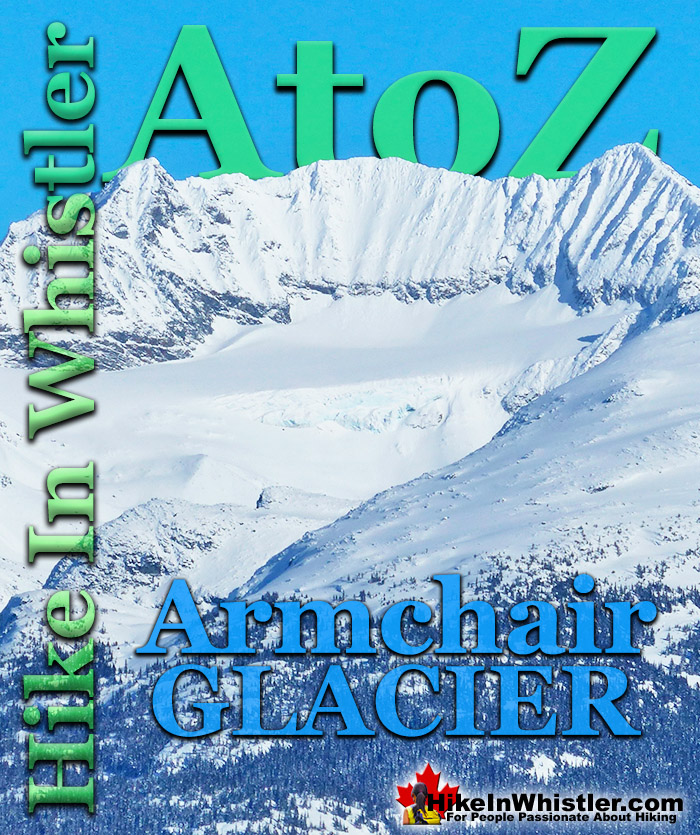
![]() Armchair Glacier is one of the many easily identifiable mountain features around Whistler. Along with Wedge Mountain and Black Tusk, Armchair Glacier has a distinct shape that it is named after. Armchair Glacier can be seen from a considerable distance and from many places in Whistler. In the winter it is a solid white ridge with three peaks and in the summer the ridge and peaks are bare rock and the glacier can be seen as a solid, horizontal line below.
Armchair Glacier is one of the many easily identifiable mountain features around Whistler. Along with Wedge Mountain and Black Tusk, Armchair Glacier has a distinct shape that it is named after. Armchair Glacier can be seen from a considerable distance and from many places in Whistler. In the winter it is a solid white ridge with three peaks and in the summer the ridge and peaks are bare rock and the glacier can be seen as a solid, horizontal line below.
Whistler & Garibaldi Hiking
![]() Alexander Falls
Alexander Falls ![]() Ancient Cedars
Ancient Cedars ![]() Black Tusk
Black Tusk ![]() Blackcomb Mountain
Blackcomb Mountain ![]() Brandywine Falls
Brandywine Falls ![]() Brandywine Meadows
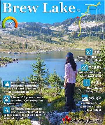
Brandywine Meadows ![]() Brew Lake
Brew Lake ![]() Callaghan Lake
Callaghan Lake ![]() Cheakamus Lake
Cheakamus Lake ![]() Cheakamus River
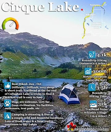
Cheakamus River ![]() Cirque Lake
Cirque Lake ![]() Flank Trail
Flank Trail ![]() Garibaldi Lake
Garibaldi Lake ![]() Garibaldi Park
Garibaldi Park ![]() Helm Creek
Helm Creek ![]() Jane Lakes
Jane Lakes ![]() Joffre Lakes
Joffre Lakes ![]() Keyhole Hot Springs
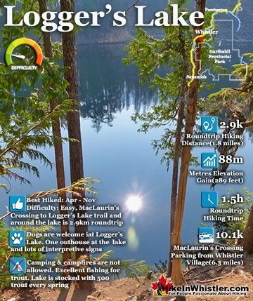
Keyhole Hot Springs ![]() Logger’s Lake
Logger’s Lake ![]() Madeley Lake
Madeley Lake ![]() Meager Hot Springs
Meager Hot Springs ![]() Nairn Falls
Nairn Falls ![]() Newt Lake
Newt Lake ![]() Panorama Ridge
Panorama Ridge ![]() Parkhurst Ghost Town
Parkhurst Ghost Town ![]() Rainbow Falls
Rainbow Falls ![]() Rainbow Lake
Rainbow Lake ![]() Ring Lake
Ring Lake ![]() Russet Lake
Russet Lake ![]() Sea to Sky Trail
Sea to Sky Trail ![]() Skookumchuck Hot Springs
Skookumchuck Hot Springs ![]() Sloquet Hot Springs
Sloquet Hot Springs ![]() Sproatt East
Sproatt East ![]() Sproatt West
Sproatt West ![]() Taylor Meadows
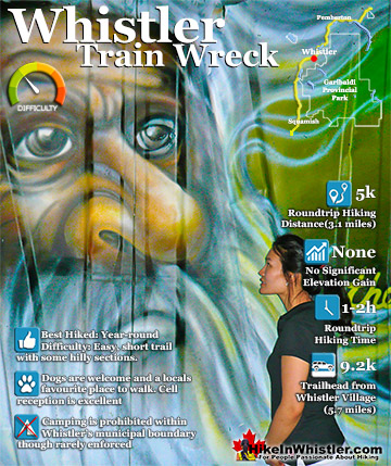
Taylor Meadows ![]() Train Wreck
Train Wreck ![]() Wedgemount Lake
Wedgemount Lake ![]() Whistler Mountain
Whistler Mountain
![]() January
January ![]() February
February ![]() March
March ![]() April
April ![]() May
May ![]() June
June ![]() July
July ![]() August
August ![]() September
September ![]() October
October ![]() November
November ![]() December
December
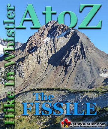
The three-peak mountain ridge above Armchair Glacier is actually called Mount Weart. Despite its distinct armchair appearance and it being known for decades as Armchair Mountain, or simply Armchair, in 1930 the Garibaldi Park Board officially had the name changed to Mount Weart. John Walter Weart(1861-1941) was a lawyer, politician and the chairman of the Garibaldi Park Board at the time of the name change. Though officially called Mount Weart by the Geographical Names Board of Canada, the original name Armchair is still almost universally used. Mount Weart is generally only used to refer to the prominent and highest of the three peaks, the southernmost peak, or the peak on the right if viewed from Whistler. This southern peak of Mount Weart marks it as the second highest mountain in Garibaldi Provincial Park at 2835 metres or 9301 feet. Weart's neighbour, Wedge Mountain is the highest peak in Garibaldi Park at 2895 metres or 9497 feet. The two summits are just 3.7 kilometres apart and joined by the Wedge-Weart Col. The Armchair Traverse is a popular, though very challenging, Class 4 route from Mount Cook to Mount Weart and descending down from the Wedge Weart Col via the Wedgemount Glacier. Highlights of the Armchair Traverse are the incredible views of Wedgemount Lake, the surrounding mountains and the enormous Weart Glacier. Weart Glacier fills the valley to the north of Mount Weart and is fantastically huge. From Mount Weart you can see over Rethel Mountain and down to Whistler Valley. Extraordinary considering how monstrously huge Rethel seems from the shore of Wedgemount Lake.

In the image below Mount Cook is on the left, Armchair Mountain aka: Mt Weart is the three peaks in the middle with the peak on the right being the second highest mountain in Garibaldi Park. The mountain in the foreground to the right is Rethel Mountain. The faint horizontal line below Armchair is Armchair Glacier. Hard to make out in February when the mountains are heavily blanketed in snow.


Mount Weart is probably the most popular of the branching hikes from Wedgemount Lake. This is because of its extraordinarily beautiful views from its summit. It is quite difficult and some tricky route finding is involved as you leave Wedgemount Glacier for the Weart ascent. But you will have trouble finding more beautiful views from another peak in the area. It is a difficult and long scramble from the Wedgemount Lake hut and a considerable elevation gain of 780 metres from the Hut. Give yourself at least four hours roundtrip, hut to hut. From the Wedge hut head down the scree valley trail to the left side of Wedgemount Lake. Continue up Wedgemount Glacier staying to the left edge of the glacier on the talus and scree as comfortably possible until you see the creek that flows from Mount Weart. Continue up the left side of this creek, this is where the scrambling becomes difficult, but only for a short while. The difficult section leads to a basin with a glacier to your right. Stay to the left edge of this glacier and make your way somewhat directly up the scree slopes until you reach the ridge leading to Weart. You will take this ridge to your left until you reach the summit.


Below is the view of Armchair Glacier from the Parkhurst Wye, though zoomed in quite a bit!


More Whistler & Garibaldi Park Hiking A to Z!

The Best Whistler & Garibaldi Park Hiking Trails!
Whistler & Garibaldi Park Best Hiking by Month!

Explore BC Hiking Destinations!
Whistler Hiking Trails
Squamish Hiking Trails
Vancouver Hiking Trails
Clayoquot Hiking Trails
Victoria Hiking Trails